

Kolesarska pot 8
A cycling route starting in Majšperk, Občina Majšperk, Slovenia.
Overview
About this route
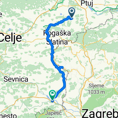
Dolžina poti: 59 kmČas vožnje: 3h 30 minZahtevnost: srednje zahtevnaPotek potiRogaška Slatina - Rogatec - Stoperce - Majšperk - Ptujska Gora (obrni) - Studenice - Poljčane - Podplat - Rogaška SlatinaVrhunec te dolge, a srednje zahtevne poti je Ptujska gora, od koder je čudovit razgled na Dravsko polje in Haloze.
- -:--
- Duration
- 80.5 km
- Distance
- 1,271 m
- Ascent
- 1,288 m
- Descent
- ---
- Avg. speed
- 390 m
- Max. altitude

Route quality
Waytypes & surfaces along the route
Waytypes
Road
7.2 km
(9 %)
Cycleway
3.2 km
(4 %)
Surfaces
Paved
35.4 km
(44 %)
Asphalt
35.4 km
(44 %)
Undefined
45.1 km
(56 %)
Continue with Bikemap
Use, edit, or download this cycling route
You would like to ride Kolesarska pot 8 or customize it for your own trip? Here is what you can do with this Bikemap route:
Free features
- Save this route as favorite or in collections
- Copy & plan your own version of this route
- Split it into stages to create a multi-day tour
- Sync your route with Garmin or Wahoo
Premium features
Free trial for 3 days, or one-time payment. More about Bikemap Premium.
- Navigate this route on iOS & Android
- Export a GPX / KML file of this route
- Create your custom printout (try it for free)
- Download this route for offline navigation
Discover more Premium features.
Get Bikemap PremiumFrom our community
Other popular routes starting in Majšperk
 MAJŠPERK LENART
- Distance
- 75.7 km
- Ascent
- 651 m
- Descent
- 650 m
- Location
- Majšperk, Občina Majšperk, Slovenia
 test1-2ver2
- Distance
- 84.7 km
- Ascent
- 480 m
- Descent
- 562 m
- Location
- Majšperk, Občina Majšperk, Slovenia
 Majšperk - Bolfenk
- Distance
- 7.6 km
- Ascent
- 382 m
- Descent
- 102 m
- Location
- Majšperk, Občina Majšperk, Slovenia
 Majšperk 3
- Distance
- 3.4 km
- Ascent
- 80 m
- Descent
- 79 m
- Location
- Majšperk, Občina Majšperk, Slovenia
 Majšperk - Rogaška - Poljčane - Loče - Bistrica
- Distance
- 65.6 km
- Ascent
- 505 m
- Descent
- 406 m
- Location
- Majšperk, Občina Majšperk, Slovenia
 Kronometer Sestrze
- Distance
- 15 km
- Ascent
- 113 m
- Descent
- 112 m
- Location
- Majšperk, Občina Majšperk, Slovenia
 Test 1
- Distance
- 3.6 km
- Ascent
- 0 m
- Descent
- 59 m
- Location
- Majšperk, Občina Majšperk, Slovenia
 Haloze
- Distance
- 45 km
- Ascent
- 416 m
- Descent
- 468 m
- Location
- Majšperk, Občina Majšperk, Slovenia
Open it in the app