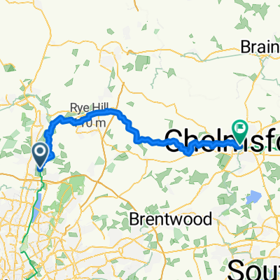
London-Edinburgh-London 1400 km Brevet
A cycling route starting in Cheshunt, England, United Kingdom.
Overview
About this route
by Audax UK 2005 nä. Termin 2009
- -:--
- Duration
- 680.5 km
- Distance
- 1,538 m
- Ascent
- 1,491 m
- Descent
- ---
- Avg. speed
- ---
- Avg. speed
Route quality
Waytypes & surfaces along the route
Waytypes
Undefined
680.5 km
(100 %)
Surfaces
Undefined
680.5 km
(100 %)
Continue with Bikemap
Use, edit, or download this cycling route
You would like to ride London-Edinburgh-London 1400 km Brevet or customize it for your own trip? Here is what you can do with this Bikemap route:
Free features
- Save this route as favorite or in collections
- Copy & plan your own version of this route
- Sync your route with Garmin or Wahoo
Premium features
Free trial for 3 days, or one-time payment. More about Bikemap Premium.
- Navigate this route on iOS & Android
- Export a GPX / KML file of this route
- Create your custom printout (try it for free)
- Download this route for offline navigation
Discover more Premium features.
Get Bikemap PremiumFrom our community
Other popular routes starting in Cheshunt
- Cheshunt to Cambridge
- Distance
- 72.8 km
- Ascent
- 213 m
- Descent
- 219 m
- Location
- Cheshunt, England, United Kingdom
- Route from 15 Roundmoor Drive, Waltham Cross
- Distance
- 3.7 km
- Ascent
- 0 m
- Descent
- 0 m
- Location
- Cheshunt, England, United Kingdom
- Hayden Court 228, Cheshunt to Saint Andrew Street Car Park
- Distance
- 23.9 km
- Ascent
- 182 m
- Descent
- 163 m
- Location
- Cheshunt, England, United Kingdom
- Moderate route in London
- Distance
- 24.8 km
- Ascent
- 93 m
- Descent
- 74 m
- Location
- Cheshunt, England, United Kingdom
- Cheshunt Family ride 2
- Distance
- 16.5 km
- Ascent
- 56 m
- Descent
- 58 m
- Location
- Cheshunt, England, United Kingdom
- national cycle route
- Distance
- 14.2 km
- Ascent
- 47 m
- Descent
- 44 m
- Location
- Cheshunt, England, United Kingdom
- MTB-Family Chesnut ride
- Distance
- 9.7 km
- Ascent
- 21 m
- Descent
- 20 m
- Location
- Cheshunt, England, United Kingdom
- Lee navigation route
- Distance
- 14.9 km
- Ascent
- 46 m
- Descent
- 46 m
- Location
- Cheshunt, England, United Kingdom