

Overview
About this route
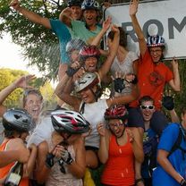
A Váci Piár római kerékpáros zarándoklata 2012-ben és 2017-ben
- -:--
- Duration
- 1,115.6 km
- Distance
- 1,691 m
- Ascent
- 1,793 m
- Descent
- ---
- Avg. speed
- ---
- Max. altitude

Part of
Róma 2017.
1 stage
Route quality
Waytypes & surfaces along the route
Waytypes
Quiet road
167.3 km
(15 %)
Cycleway
100.4 km
(9 %)
Surfaces
Paved
736.3 km
(66 %)
Unpaved
33.5 km
(3 %)
Asphalt
725.1 km
(65 %)
Gravel
22.3 km
(2 %)
Continue with Bikemap
Use, edit, or download this cycling route
You would like to ride RÓMA TELJES 2012-2017. or customize it for your own trip? Here is what you can do with this Bikemap route:
Free features
- Save this route as favorite or in collections
- Copy & plan your own version of this route
- Split it into stages to create a multi-day tour
- Sync your route with Garmin or Wahoo
Premium features
Free trial for 3 days, or one-time payment. More about Bikemap Premium.
- Navigate this route on iOS & Android
- Export a GPX / KML file of this route
- Create your custom printout (try it for free)
- Download this route for offline navigation
Discover more Premium features.
Get Bikemap PremiumFrom our community
Other popular routes starting in Nagykanizsa
 Obornak Várdomb kör
- Distance
- 14.7 km
- Ascent
- 343 m
- Descent
- 349 m
- Location
- Nagykanizsa, Zala County, Hungary
 Látóhegy - Gáspár-hegy - Nagyrécse - Bacónaki-hegy - Cserfő
- Distance
- 33.4 km
- Ascent
- 391 m
- Descent
- 390 m
- Location
- Nagykanizsa, Zala County, Hungary
 Murafölde kör 1
- Distance
- 220.7 km
- Ascent
- 1,244 m
- Descent
- 1,244 m
- Location
- Nagykanizsa, Zala County, Hungary
 Murafölde kör 3
- Distance
- 219.8 km
- Ascent
- 2,889 m
- Descent
- 2,891 m
- Location
- Nagykanizsa, Zala County, Hungary
 Börzönce1
- Distance
- 65.4 km
- Ascent
- 327 m
- Descent
- 327 m
- Location
- Nagykanizsa, Zala County, Hungary
 Murafölde kör 2
- Distance
- 222 km
- Ascent
- 3,042 m
- Descent
- 3,043 m
- Location
- Nagykanizsa, Zala County, Hungary
 Tengerre magyar 1.st day
- Distance
- 174.9 km
- Ascent
- 410 m
- Descent
- 437 m
- Location
- Nagykanizsa, Zala County, Hungary
 Vörös-hegyi kör
- Distance
- 33.1 km
- Ascent
- 197 m
- Descent
- 203 m
- Location
- Nagykanizsa, Zala County, Hungary
Open it in the app