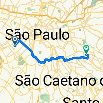
- 42.6 km
- 2,046 m
- 1,997 m
- São Paulo, São Paulo, Brazil
Tatuapé>Centro>Sesc Pompéia (ruas +tranquilas)
A cycling route starting in São Paulo, São Paulo, Brazil.
Overview
About this route
This route is more difficult to remember but avoids all the viaducts, major avenues in the east zone and downtown area, as well as the toughest climbs in the Perdizes region.
- -:--
- Duration
- 15.2 km
- Distance
- 111 m
- Ascent
- 125 m
- Descent
- ---
- Avg. speed
- ---
- Max. altitude
created this 13 years ago
Route quality
Waytypes & surfaces along the route
Waytypes
Road
7.1 km
(47 %)
Quiet road
3.9 km
(26 %)
Surfaces
Paved
15 km
(99 %)
Asphalt
14.1 km
(93 %)
Concrete
0.6 km
(4 %)
Route highlights
Points of interest along the route
Point of interest after 0.1 km
Empurre a bike desmontado para passar da ciclovia até o outro lado do metrô.
Point of interest after 6.4 km
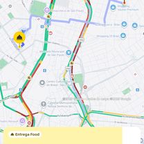
Uma das partes mais movimentadas do trajeto. No entanto, essa rua vive congestionada. Depois de virar na avenida dos tiradentes, ela fica tranquila novamente.
Point of interest after 12.7 km
Caso não se sinta confortável de subir a ministro godói e pedalar pela turiassu, é possível usar a calçada da Av. Franscisco Matarazzo até o Sesc Pompéia. Ela é larga e é possível de pedalar por lá, desde que se respeite a preferência dos pedestres..
Continue with Bikemap
Use, edit, or download this cycling route
You would like to ride Tatuapé>Centro>Sesc Pompéia (ruas +tranquilas) or customize it for your own trip? Here is what you can do with this Bikemap route:
Free features
- Save this route as favorite or in collections
- Copy & plan your own version of this route
- Sync your route with Garmin or Wahoo
Premium features
Free trial for 3 days, or one-time payment. More about Bikemap Premium.
- Navigate this route on iOS & Android
- Export a GPX / KML file of this route
- Create your custom printout (try it for free)
- Download this route for offline navigation
Discover more Premium features.
Get Bikemap PremiumFrom our community
Other popular routes starting in São Paulo
- De Rua Turquia a Avenida Cidade Jardim
- Pte. estaiada / centro
- 12 km
- 160 m
- 124 m
- São Paulo, São Paulo, Brazil
- De Travessa Lúcia Albertina Soares Quadros a Praça Waldomiro Maluhy
- 43.4 km
- 2,017 m
- 2,021 m
- São Paulo, São Paulo, Brazil
- Paulista Brooklin
- 8.2 km
- 94 m
- 152 m
- São Paulo, São Paulo, Brazil
- Tatuapé>Centro>Sesc Pompéia (ruas +tranquilas)
- 15.2 km
- 111 m
- 125 m
- São Paulo, São Paulo, Brazil
- De Avenida Brigadeiro Faria Lima a Avenida Cidade Jardim
- 21.5 km
- 440 m
- 436 m
- São Paulo, São Paulo, Brazil
- De Rua Antônio Guganis a Rua Silva Teles
- 33.2 km
- 273 m
- 286 m
- São Paulo, São Paulo, Brazil
- L+SND - CAMPO DE MARTE
- 40.6 km
- 163 m
- 163 m
- São Paulo, São Paulo, Brazil
Open it in the app


