Allwrong LEJOG Tour - Day 2
A cycling route starting in Tintagel, England, United Kingdom.
Overview
About this route
Allwrong LEJOG Tour - Day 2
Â
Tintagel to Taunton
Â
147.2 km = 91.5 miles
- -:--
- Duration
- 147.2 km
- Distance
- 820 m
- Ascent
- 895 m
- Descent
- ---
- Avg. speed
- ---
- Max. altitude
Route quality
Waytypes & surfaces along the route
Waytypes
Busy road
59.6 km
(41 %)
Quiet road
34.1 km
(23 %)
Surfaces
Paved
82.9 km
(56 %)
Unpaved
0.3 km
(<1 %)
Asphalt
69.8 km
(47 %)
Paved (undefined)
13 km
(9 %)
Continue with Bikemap
Use, edit, or download this cycling route
You would like to ride Allwrong LEJOG Tour - Day 2 or customize it for your own trip? Here is what you can do with this Bikemap route:
Free features
- Save this route as favorite or in collections
- Copy & plan your own version of this route
- Split it into stages to create a multi-day tour
- Sync your route with Garmin or Wahoo
Premium features
Free trial for 3 days, or one-time payment. More about Bikemap Premium.
- Navigate this route on iOS & Android
- Export a GPX / KML file of this route
- Create your custom printout (try it for free)
- Download this route for offline navigation
Discover more Premium features.
Get Bikemap PremiumFrom our community
Other popular routes starting in Tintagel
- J-32: Tintagel - Newquay, méchant vent de face
- Distance
- 60.5 km
- Ascent
- 496 m
- Descent
- 552 m
- Location
- Tintagel, England, United Kingdom
- LEJO'G 03 Tintagel to Appledore
- Distance
- 98.5 km
- Ascent
- 1,436 m
- Descent
- 1,449 m
- Location
- Tintagel, England, United Kingdom
- Holiday ride
- Distance
- 23.8 km
- Ascent
- 536 m
- Descent
- 535 m
- Location
- Tintagel, England, United Kingdom
- Tintagel - Bude
- Distance
- 31.8 km
- Ascent
- 578 m
- Descent
- 663 m
- Location
- Tintagel, England, United Kingdom
- Snail-like route in Tintagel
- Distance
- 1.2 km
- Ascent
- 28 m
- Descent
- 33 m
- Location
- Tintagel, England, United Kingdom
- Tintagel-kleine_Runde
- Distance
- 27.9 km
- Ascent
- 523 m
- Descent
- 523 m
- Location
- Tintagel, England, United Kingdom
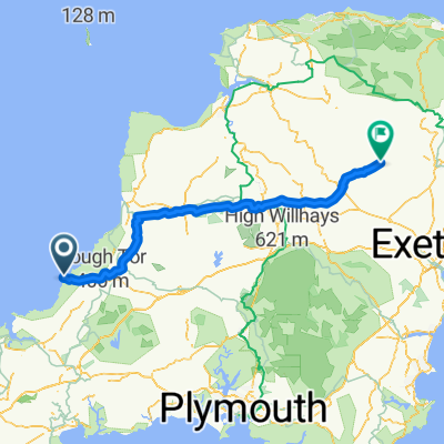
- leJog stage 2 Boscastle to Stogumber
- Distance
- 133.2 km
- Ascent
- 1,441 m
- Descent
- 1,409 m
- Location
- Tintagel, England, United Kingdom
- 8.etapa Tintagel (Headland) - Headley Wood
- Distance
- 43.6 km
- Ascent
- 681 m
- Descent
- 681 m
- Location
- Tintagel, England, United Kingdom
Open it in the app