

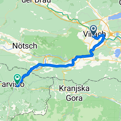
28.6. Villach - Kranjska Gora
A cycling route starting in Villach, Carinthia, Austria.
Overview
About this route
Etappe 6: I dag sykler vi i 3 land, og kommer inn i kanskje det fineste området på turen. Vi sykler mot Italia på "Alpe Adria radweg" og skal opp ca. 200 høydemeter. Etter grensepasseringen sykler vi videre til Tarvisio, en koselig landsby i utrolige omgivelser og synet av "Julian alps". Vi sykler så mot Slovenia og Kranjska Gora, kjent for verdenscup i alpint. Underveis nyter vi bare synet Julian alps og krysser grensen inn til Slovenia, på det som kan kalles syklenes "autobane". Strekningen har en lang jevn stigning før det går slakt utfor til målet for dagen. 2 netter i Kranjska Gora, med muligheter for tur til Bled eller andre aktiviteter i området. Overnatting: Berghi Hotel and Apartments. Høydepunkter Italia, Julian Alps, Grense Slovenia, Lago di Fusine.
- 4 h 8 min
- Duration
- 62.1 km
- Distance
- 1,272 m
- Ascent
- 972 m
- Descent
- 15 km/h
- Avg. speed
- 972 m
- Max. altitude

Route photos


Route quality
Waytypes & surfaces along the route
Waytypes
Cycleway
46 km
(74 %)
Quiet road
10.6 km
(17 %)
Surfaces
Paved
51.6 km
(83 %)
Unpaved
5 km
(8 %)
Asphalt
34.2 km
(55 %)
Paved (undefined)
17.4 km
(28 %)
Route highlights
Points of interest along the route

Point of interest after 49.8 km
Lago di Fusine
Continue with Bikemap
Use, edit, or download this cycling route
You would like to ride 28.6. Villach - Kranjska Gora or customize it for your own trip? Here is what you can do with this Bikemap route:
Free features
- Save this route as favorite or in collections
- Copy & plan your own version of this route
- Sync your route with Garmin or Wahoo
Premium features
Free trial for 3 days, or one-time payment. More about Bikemap Premium.
- Navigate this route on iOS & Android
- Export a GPX / KML file of this route
- Create your custom printout (try it for free)
- Download this route for offline navigation
Discover more Premium features.
Get Bikemap PremiumFrom our community
Other popular routes starting in Villach
 05 Villach - Tarvisio
- Distance
- 35.7 km
- Ascent
- 656 m
- Descent
- 434 m
- Location
- Villach, Carinthia, Austria
 Ossiacher See - Moosburg - WörtherSee
- Distance
- 73.2 km
- Ascent
- 910 m
- Descent
- 913 m
- Location
- Villach, Carinthia, Austria
 12.10. Villach nach Wörthersee zurück Maria Loretto
- Distance
- 78.3 km
- Ascent
- 797 m
- Descent
- 800 m
- Location
- Villach, Carinthia, Austria
 Feldnerstrasse 15, Villach to Via Monfalcone, Grado
- Distance
- 220.4 km
- Ascent
- 2,076 m
- Descent
- 2,585 m
- Location
- Villach, Carinthia, Austria
 3Länder Villach-Slowenien-Italien-Villach CLONED FROM ROUTE 383964
- Distance
- 91.3 km
- Ascent
- 1,126 m
- Descent
- 1,129 m
- Location
- Villach, Carinthia, Austria
 Villach / Parenzana
- Distance
- 340.5 km
- Ascent
- 4,369 m
- Descent
- 4,863 m
- Location
- Villach, Carinthia, Austria
 Oswaldiberg
- Distance
- 7.2 km
- Ascent
- 461 m
- Descent
- 4 m
- Location
- Villach, Carinthia, Austria
 Girolibero: Laghi della Carinzia
- Distance
- 229.2 km
- Ascent
- 2,100 m
- Descent
- 2,082 m
- Location
- Villach, Carinthia, Austria
Open it in the app