

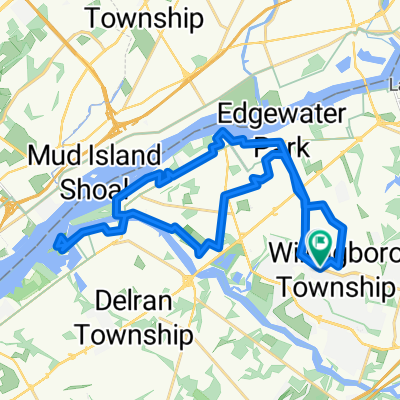
Out to Medford
A cycling route starting in Willingboro, New Jersey, United States of America.
Overview
About this route
Medford/Mt Laurel/Moorestown and back
- -:--
- Duration
- 61.4 km
- Distance
- 212 m
- Ascent
- 208 m
- Descent
- ---
- Avg. speed
- 41 m
- Avg. speed

Route quality
Waytypes & surfaces along the route
Waytypes
Road
27.4 km
(45 %)
Quiet road
18.5 km
(30 %)
Surfaces
Paved
9.2 km
(15 %)
Unpaved
0.4 km
(<1 %)
Asphalt
8.8 km
(14 %)
Unpaved (undefined)
0.4 km
(<1 %)
Continue with Bikemap
Use, edit, or download this cycling route
You would like to ride Out to Medford or customize it for your own trip? Here is what you can do with this Bikemap route:
Free features
- Save this route as favorite or in collections
- Copy & plan your own version of this route
- Sync your route with Garmin or Wahoo
Premium features
Free trial for 3 days, or one-time payment. More about Bikemap Premium.
- Navigate this route on iOS & Android
- Export a GPX / KML file of this route
- Create your custom printout (try it for free)
- Download this route for offline navigation
Discover more Premium features.
Get Bikemap PremiumFrom our community
Other popular routes starting in Willingboro
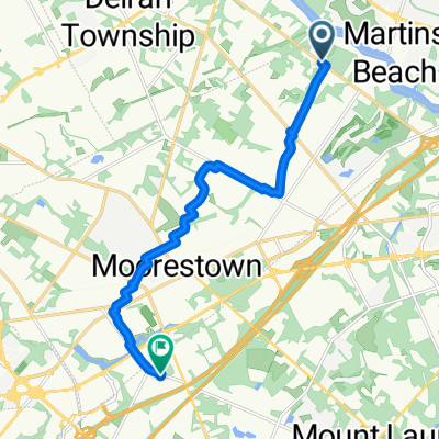 Tudor Ln, Moorestown to E Gate Dr, Mount Laurel
- Distance
- 12 km
- Ascent
- 38 m
- Descent
- 42 m
- Location
- Willingboro, New Jersey, United States of America
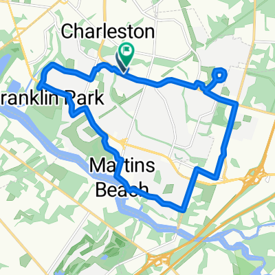 Meribrook Circle to Meribrook Circle
- Distance
- 16.4 km
- Ascent
- 91 m
- Descent
- 57 m
- Location
- Willingboro, New Jersey, United States of America
 16 Lake Dr, Mount Laurel to 18 Lake Dr, Mount Laurel
- Distance
- 9.3 km
- Ascent
- 93 m
- Descent
- 135 m
- Location
- Willingboro, New Jersey, United States of America
 11 Parson Ln, Willingboro to 1320 Neck Rd, Burlington
- Distance
- 10.1 km
- Ascent
- 3 m
- Descent
- 3 m
- Location
- Willingboro, New Jersey, United States of America
 Levitt Pkwy, Willingboro to 711 Public Rd, Palmyra
- Distance
- 18.5 km
- Ascent
- 134 m
- Descent
- 139 m
- Location
- Willingboro, New Jersey, United States of America
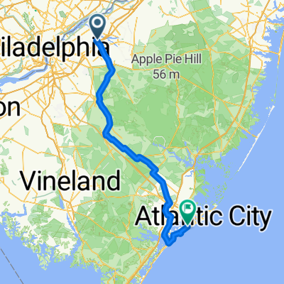 Hogan Way, Moorestown to N Rosborough Ave, Ventnor City
- Distance
- 116.4 km
- Ascent
- 238 m
- Descent
- 255 m
- Location
- Willingboro, New Jersey, United States of America
 Out to Medford
- Distance
- 61.4 km
- Ascent
- 212 m
- Descent
- 208 m
- Location
- Willingboro, New Jersey, United States of America
 Meribrook Circle to Meribrook Circle
- Distance
- 34.6 km
- Ascent
- 75 m
- Descent
- 36 m
- Location
- Willingboro, New Jersey, United States of America
Open it in the app