NCR 41
A cycling route starting in Stonehouse, England, United Kingdom.
Overview
About this route
- -:--
- Duration
- 46.3 km
- Distance
- 246 m
- Ascent
- 245 m
- Descent
- ---
- Avg. speed
- 104 m
- Avg. speed
Route quality
Waytypes & surfaces along the route
Waytypes
Quiet road
20.4 km
(44 %)
Road
11.6 km
(25 %)
Surfaces
Paved
12.8 km
(28 %)
Unpaved
1.7 km
(4 %)
Asphalt
12.8 km
(28 %)
Loose gravel
1.2 km
(3 %)
Route highlights
Points of interest along the route
Point of interest after 0.8 km
Home
Continue with Bikemap
Use, edit, or download this cycling route
You would like to ride NCR 41 or customize it for your own trip? Here is what you can do with this Bikemap route:
Free features
- Save this route as favorite or in collections
- Copy & plan your own version of this route
- Sync your route with Garmin or Wahoo
Premium features
Free trial for 3 days, or one-time payment. More about Bikemap Premium.
- Navigate this route on iOS & Android
- Export a GPX / KML file of this route
- Create your custom printout (try it for free)
- Download this route for offline navigation
Discover more Premium features.
Get Bikemap PremiumFrom our community
Other popular routes starting in Stonehouse
- berkley vale
- Distance
- 95.8 km
- Ascent
- 81 m
- Descent
- 81 m
- Location
- Stonehouse, England, United Kingdom
- Sandfield Bridgehouse, Church Lane, Gloucester to Saintbridge Road, Gloucester
- Distance
- 19.2 km
- Ascent
- 65 m
- Descent
- 51 m
- Location
- Stonehouse, England, United Kingdom
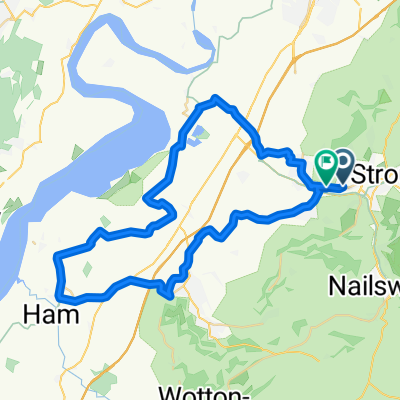
- Frampton loop of love
- Distance
- 24.5 km
- Ascent
- 80 m
- Descent
- 81 m
- Location
- Stonehouse, England, United Kingdom
- Ebley to Coaley Peak Circular
- Distance
- 16.3 km
- Ascent
- 270 m
- Descent
- 270 m
- Location
- Stonehouse, England, United Kingdom
- praca w uk
- Distance
- 18.5 km
- Ascent
- 31 m
- Descent
- 26 m
- Location
- Stonehouse, England, United Kingdom
- National Cycle Network 45 (Mercian Way) Ebley - Cirencester
- Distance
- 33.3 km
- Ascent
- 351 m
- Descent
- 279 m
- Location
- Stonehouse, England, United Kingdom
- NCR 41
- Distance
- 46.3 km
- Ascent
- 246 m
- Descent
- 245 m
- Location
- Stonehouse, England, United Kingdom
- Oatfield Road, Frampton on Severn to Iddesleigh Road 1
- Distance
- 52.5 km
- Ascent
- 455 m
- Descent
- 370 m
- Location
- Stonehouse, England, United Kingdom
Open it in the app