
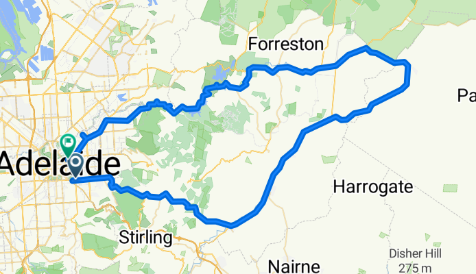
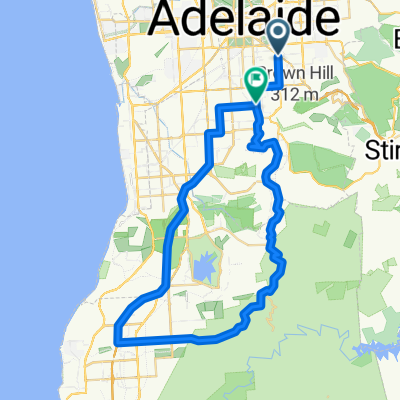
the Jesus loop
A cycling route starting in Fullarton, South Australia, Australia.
Overview
About this route
- -:--
- Duration
- 113.9 km
- Distance
- 903 m
- Ascent
- 929 m
- Descent
- ---
- Avg. speed
- ---
- Max. altitude
Route quality
Waytypes & surfaces along the route
Waytypes
Quiet road
15.9 km
(14 %)
Cycleway
4.6 km
(4 %)
Surfaces
Paved
109.4 km
(96 %)
Asphalt
70.6 km
(62 %)
Paved (undefined)
38.7 km
(34 %)
Undefined
4.6 km
(4 %)
Continue with Bikemap
Use, edit, or download this cycling route
You would like to ride the Jesus loop or customize it for your own trip? Here is what you can do with this Bikemap route:
Free features
- Save this route as favorite or in collections
- Copy & plan your own version of this route
- Split it into stages to create a multi-day tour
- Sync your route with Garmin or Wahoo
Premium features
Free trial for 3 days, or one-time payment. More about Bikemap Premium.
- Navigate this route on iOS & Android
- Export a GPX / KML file of this route
- Create your custom printout (try it for free)
- Download this route for offline navigation
Discover more Premium features.
Get Bikemap PremiumFrom our community
Other popular routes starting in Fullarton
 Greenhill slog 20 3 10
- Distance
- 47 km
- Ascent
- 824 m
- Descent
- 827 m
- Location
- Fullarton, South Australia, Australia
 Hills via Gorge, Lobethal, Woodside down Greenhill Road
- Distance
- 81.8 km
- Ascent
- 980 m
- Descent
- 668 m
- Location
- Fullarton, South Australia, Australia
 Myrtle Bank to Tanunda
- Distance
- 99.1 km
- Ascent
- 316 m
- Descent
- 169 m
- Location
- Fullarton, South Australia, Australia
 the Jesus loop
- Distance
- 113.9 km
- Ascent
- 903 m
- Descent
- 929 m
- Location
- Fullarton, South Australia, Australia
 PhD Zooms
- Distance
- 6.4 km
- Ascent
- 40 m
- Descent
- 61 m
- Location
- Fullarton, South Australia, Australia
 Coromandel Valley and Sthern bikeway
- Distance
- 57 km
- Ascent
- 653 m
- Descent
- 644 m
- Location
- Fullarton, South Australia, Australia
 Clarendon - Scott Creek - Stirling
- Distance
- 68.5 km
- Ascent
- 976 m
- Descent
- 976 m
- Location
- Fullarton, South Australia, Australia
 "Over the top"
- Distance
- 40.6 km
- Ascent
- 672 m
- Descent
- 672 m
- Location
- Fullarton, South Australia, Australia
Open it in the app