

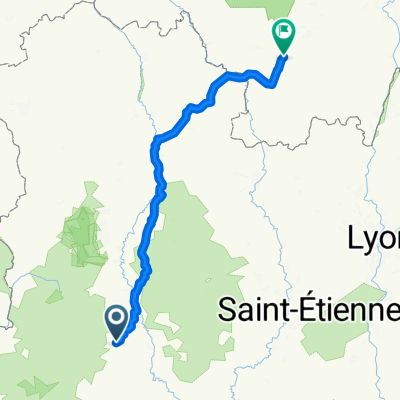
Deutschland - Portugal (Berlin - Faro) FR 21 Massiac - Allanche
A cycling route starting in Massiac, Auvergne-Rhône-Alpes, France.
Overview
About this route
Radroute V74 - The Great Volcano Crossing by Bike, further upwards
- -:--
- Duration
- 27 km
- Distance
- 651 m
- Ascent
- 237 m
- Descent
- ---
- Avg. speed
- 1,246 m
- Max. altitude

Route photos
 FR 21 Massiac - Allanche\"")
 FR 21 Massiac - Allanche\"")
 FR 21 Massiac - Allanche\"")
 FR 21 Massiac - Allanche\"")
Route quality
Waytypes & surfaces along the route
Waytypes
Quiet road
2.2 km
(8 %)
Undefined
24.8 km
(92 %)
Surfaces
Paved
3 km
(11 %)
Asphalt
3 km
(11 %)
Undefined
24 km
(89 %)
Continue with Bikemap
Use, edit, or download this cycling route
You would like to ride Deutschland - Portugal (Berlin - Faro) FR 21 Massiac - Allanche or customize it for your own trip? Here is what you can do with this Bikemap route:
Free features
- Save this route as favorite or in collections
- Copy & plan your own version of this route
- Sync your route with Garmin or Wahoo
Premium features
Free trial for 3 days, or one-time payment. More about Bikemap Premium.
- Navigate this route on iOS & Android
- Export a GPX / KML file of this route
- Create your custom printout (try it for free)
- Download this route for offline navigation
Discover more Premium features.
Get Bikemap PremiumFrom our community
Other popular routes starting in Massiac
 Blesle - Marzun - Chadecol
- Distance
- 24.9 km
- Ascent
- 657 m
- Descent
- 659 m
- Location
- Massiac, Auvergne-Rhône-Alpes, France
 Cézallier Sud
- Distance
- 115.8 km
- Ascent
- 1,503 m
- Descent
- 1,500 m
- Location
- Massiac, Auvergne-Rhône-Alpes, France
 TDF dg2 47k Saint Flour
- Distance
- 47.3 km
- Ascent
- 776 m
- Descent
- 398 m
- Location
- Massiac, Auvergne-Rhône-Alpes, France
 De La Bessière, Blesle à D246, Mandailles-Saint-Julien
- Distance
- 77.5 km
- Ascent
- 1,727 m
- Descent
- 1,359 m
- Location
- Massiac, Auvergne-Rhône-Alpes, France
 10) Le Pays coupé on edp-parcours.com
- Distance
- 21.8 km
- Ascent
- 483 m
- Descent
- 483 m
- Location
- Massiac, Auvergne-Rhône-Alpes, France
 24-25
24-25- Distance
- 223.5 km
- Ascent
- 576 m
- Descent
- 829 m
- Location
- Massiac, Auvergne-Rhône-Alpes, France
 Route in Blesle
- Distance
- 23.2 km
- Ascent
- 451 m
- Descent
- 452 m
- Location
- Massiac, Auvergne-Rhône-Alpes, France
 Deutschland - Portugal (Berlin - Faro) FR 21 Massiac - Allanche
- Distance
- 27 km
- Ascent
- 651 m
- Descent
- 237 m
- Location
- Massiac, Auvergne-Rhône-Alpes, France
Open it in the app