

Girolibero: Perigord
A cycling route starting in Saint-Cyprien, Nouvelle-Aquitaine, France.
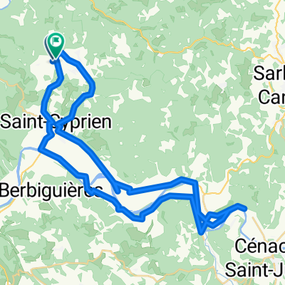
Overview
About this route
Overnight stays: Castels, Roque-Gageac, Sarlat, Saint Amand de Coly/Montignac, Marquay/Les Eyzies.
- -:--
- Duration
- 252.8 km
- Distance
- 1,021 m
- Ascent
- 1,024 m
- Descent
- ---
- Avg. speed
- ---
- Max. altitude

Route quality
Waytypes & surfaces along the route
Waytypes
Road
88.5 km
(35 %)
Quiet road
25.3 km
(10 %)
Surfaces
Paved
176.9 km
(70 %)
Asphalt
176.9 km
(70 %)
Undefined
75.8 km
(30 %)
Route highlights
Points of interest along the route
Accommodation after 0 km
Castels
Point of interest after 22 km
Limeuil
Accommodation after 59 km
Roque_Gageac
Point of interest after 64.8 km
Domme
Accommodation after 104.8 km
Saint Amand de Coly
Accommodation after 142.6 km
Sarlat
Point of interest after 194.2 km
Montignac
Accommodation after 228.7 km
Marquay
Point of interest after 241.9 km
Les Eyzies
Continue with Bikemap
Use, edit, or download this cycling route
You would like to ride Girolibero: Perigord or customize it for your own trip? Here is what you can do with this Bikemap route:
Free features
- Save this route as favorite or in collections
- Copy & plan your own version of this route
- Split it into stages to create a multi-day tour
- Sync your route with Garmin or Wahoo
Premium features
Free trial for 3 days, or one-time payment. More about Bikemap Premium.
- Navigate this route on iOS & Android
- Export a GPX / KML file of this route
- Create your custom printout (try it for free)
- Download this route for offline navigation
Discover more Premium features.
Get Bikemap PremiumFrom our community
Other popular routes starting in Saint-Cyprien
 Perigord 2
- Distance
- 48.6 km
- Ascent
- 231 m
- Descent
- 241 m
- Location
- Saint-Cyprien, Nouvelle-Aquitaine, France
 Girolibero: Perigord per famiglie
- Distance
- 75.5 km
- Ascent
- 1,020 m
- Descent
- 979 m
- Location
- Saint-Cyprien, Nouvelle-Aquitaine, France
 D: Saint-Vincent-de-Cosse - Margaux, 4.Etappe-Genf Bordeaux
- Distance
- 190.4 km
- Ascent
- 301 m
- Descent
- 379 m
- Location
- Saint-Cyprien, Nouvelle-Aquitaine, France
 Dordogne - 37 km
- Distance
- 37.4 km
- Ascent
- 463 m
- Descent
- 484 m
- Location
- Saint-Cyprien, Nouvelle-Aquitaine, France
 Castang nach Sarlat
- Distance
- 59.2 km
- Ascent
- 575 m
- Descent
- 550 m
- Location
- Saint-Cyprien, Nouvelle-Aquitaine, France
 Rondje zonder Lars
- Distance
- 40.3 km
- Ascent
- 511 m
- Descent
- 528 m
- Location
- Saint-Cyprien, Nouvelle-Aquitaine, France
 Perigord 3
- Distance
- 52.2 km
- Ascent
- 501 m
- Descent
- 501 m
- Location
- Saint-Cyprien, Nouvelle-Aquitaine, France
 D: Saint-Vincent-de-Cosse - Margaux, Genf-Bordeaux: 4. Etappe
- Distance
- 188.1 km
- Ascent
- 263 m
- Descent
- 333 m
- Location
- Saint-Cyprien, Nouvelle-Aquitaine, France
Open it in the app