

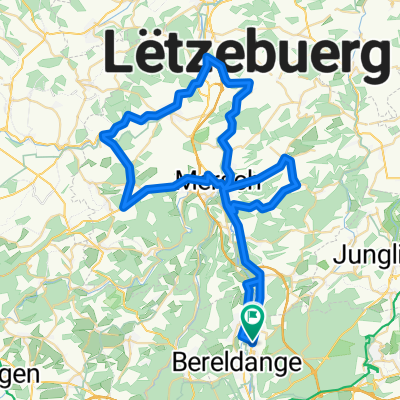
VU Route#4
A cycling route starting in Heisdorf-sur-Alzette, District de Luxembourg, Luxembourg.
Overview
About this route
- -:--
- Duration
- 39.3 km
- Distance
- 482 m
- Ascent
- 482 m
- Descent
- ---
- Avg. speed
- 405 m
- Max. altitude
Route quality
Waytypes & surfaces along the route
Waytypes
Busy road
10 km
(26 %)
Track
8.1 km
(21 %)
Surfaces
Paved
39.1 km
(100 %)
Asphalt
35.9 km
(91 %)
Concrete
2.2 km
(6 %)
Continue with Bikemap
Use, edit, or download this cycling route
You would like to ride VU Route#4 or customize it for your own trip? Here is what you can do with this Bikemap route:
Free features
- Save this route as favorite or in collections
- Copy & plan your own version of this route
- Sync your route with Garmin or Wahoo
Premium features
Free trial for 3 days, or one-time payment. More about Bikemap Premium.
- Navigate this route on iOS & Android
- Export a GPX / KML file of this route
- Create your custom printout (try it for free)
- Download this route for offline navigation
Discover more Premium features.
Get Bikemap PremiumFrom our community
Other popular routes starting in Heisdorf-sur-Alzette
 Itinéraire facile en Walferdange
- Distance
- 6.8 km
- Ascent
- 22 m
- Descent
- 58 m
- Location
- Heisdorf-sur-Alzette, District de Luxembourg, Luxembourg
 Training - flat 40K
- Distance
- 41.3 km
- Ascent
- 246 m
- Descent
- 246 m
- Location
- Heisdorf-sur-Alzette, District de Luxembourg, Luxembourg
 VU Route#4
- Distance
- 39.3 km
- Ascent
- 482 m
- Descent
- 482 m
- Location
- Heisdorf-sur-Alzette, District de Luxembourg, Luxembourg
 Boevange-Attert - Angelberg - Schoos
- Distance
- 64.3 km
- Ascent
- 411 m
- Descent
- 411 m
- Location
- Heisdorf-sur-Alzette, District de Luxembourg, Luxembourg
 A Forest Tour
- Distance
- 12 km
- Ascent
- 227 m
- Descent
- 226 m
- Location
- Heisdorf-sur-Alzette, District de Luxembourg, Luxembourg
 Walfer - Rollingen - Schoos - Blaschette - Walfer
- Distance
- 29.4 km
- Ascent
- 355 m
- Descent
- 356 m
- Location
- Heisdorf-sur-Alzette, District de Luxembourg, Luxembourg
 W Heisdorf - 6 princesses
- Distance
- 8.2 km
- Ascent
- 233 m
- Descent
- 233 m
- Location
- Heisdorf-sur-Alzette, District de Luxembourg, Luxembourg
 Walferdange - Trier
- Distance
- 50.5 km
- Ascent
- 265 m
- Descent
- 368 m
- Location
- Heisdorf-sur-Alzette, District de Luxembourg, Luxembourg
Open it in the app