

Steady ride
A cycling route starting in Mukono, Central Region, Uganda.
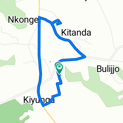
Overview
About this route
- 18 min
- Duration
- 0.9 km
- Distance
- 46 m
- Ascent
- 10 m
- Descent
- 3.1 km/h
- Avg. speed
- 1,200 m
- Max. altitude

Route photos

Route quality
Waytypes & surfaces along the route
Waytypes
Road
0.2 km
(18 %)
Undefined
0.7 km
(82 %)
Surfaces
Paved
0.7 km
(82 %)
Unpaved
0.2 km
(18 %)
Asphalt
0.7 km
(82 %)
Unpaved (undefined)
0.2 km
(18 %)
Continue with Bikemap
Use, edit, or download this cycling route
You would like to ride Steady ride or customize it for your own trip? Here is what you can do with this Bikemap route:
Free features
- Save this route as favorite or in collections
- Copy & plan your own version of this route
- Sync your route with Garmin or Wahoo
Premium features
Free trial for 3 days, or one-time payment. More about Bikemap Premium.
- Navigate this route on iOS & Android
- Export a GPX / KML file of this route
- Create your custom printout (try it for free)
- Download this route for offline navigation
Discover more Premium features.
Get Bikemap PremiumFrom our community
Other popular routes starting in Mukono
 Uganda Martyrs - Bicycle day
- Distance
- 44.7 km
- Ascent
- 483 m
- Descent
- 465 m
- Location
- Mukono, Central Region, Uganda
 FQG3+C8F to FQF2+FJ, Kiyunga
- Distance
- 27.7 km
- Ascent
- 275 m
- Descent
- 264 m
- Location
- Mukono, Central Region, Uganda
 Bukerere Road to FQF2+FJ, Kiyunga
- Distance
- 42.7 km
- Ascent
- 553 m
- Descent
- 559 m
- Location
- Mukono, Central Region, Uganda
 Heroes day Cycling 23
- Distance
- 57.9 km
- Ascent
- 707 m
- Descent
- 701 m
- Location
- Mukono, Central Region, Uganda
 FQG3+C8F to FQG3+R6R
- Distance
- 9.4 km
- Ascent
- 129 m
- Descent
- 116 m
- Location
- Mukono, Central Region, Uganda
 morning excersise130623
- Distance
- 7.4 km
- Ascent
- 110 m
- Descent
- 113 m
- Location
- Mukono, Central Region, Uganda
 Kampala–Jinja Highway to Mukono
- Distance
- 32.6 km
- Ascent
- 416 m
- Descent
- 430 m
- Location
- Mukono, Central Region, Uganda
 Eid Mubarak Topowa route
- Distance
- 41.8 km
- Ascent
- 477 m
- Descent
- 504 m
- Location
- Mukono, Central Region, Uganda
Open it in the app