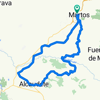
Albendin,laguna de El Salobral,Martos
A cycling route starting in Martos, Andalusia, Spain.
Overview
About this route
The itinerary is as follows: we leave Martos and head towards Albendín, continuing towards the Vadomojón reservoir. We continue along a winding, hilly regional road in the direction of the lagoon. We cross the Subbética greenway and come out onto the Baena road, where we turn left towards Alcaudete. We reach the junction and turn left heading back to Martos. This is a road route with olive grove landscapes. The first section to the lagoon has very little traffic; on the second section to Martos, extra caution is required due to cars, and riding on the shoulder is advised. It is a good route for building endurance. Depending on the season, many types of birds can be seen at the lagoon. It is a hilly route suitable for cyclists of intermediate skill level.
- -:--
- Duration
- 76.1 km
- Distance
- 958 m
- Ascent
- 956 m
- Descent
- ---
- Avg. speed
- ---
- Max. altitude
Continue with Bikemap
Use, edit, or download this cycling route
You would like to ride Albendin,laguna de El Salobral,Martos or customize it for your own trip? Here is what you can do with this Bikemap route:
Free features
- Save this route as favorite or in collections
- Copy & plan your own version of this route
- Sync your route with Garmin or Wahoo
Premium features
Free trial for 3 days, or one-time payment. More about Bikemap Premium.
- Navigate this route on iOS & Android
- Export a GPX / KML file of this route
- Create your custom printout (try it for free)
- Download this route for offline navigation
Discover more Premium features.
Get Bikemap PremiumFrom our community
Other popular routes starting in Martos
- SIERRA SUR de JAÉN
- Distance
- 89.9 km
- Ascent
- 1,342 m
- Descent
- 1,352 m
- Location
- Martos, Andalusia, Spain
- El Madroño,El Coracho,Las Peñuelas,Las Aceras,Lendinez,Martos
- Distance
- 43.9 km
- Ascent
- 557 m
- Descent
- 557 m
- Location
- Martos, Andalusia, Spain
- La mella,Fuente el palo,solana de Jabalcuz,La Grana,Martos
- Distance
- 58.9 km
- Ascent
- 1,149 m
- Descent
- 1,140 m
- Location
- Martos, Andalusia, Spain
- Sierra Ahillos por fuente amuña,presa viboras,Martos por el Alamillo
- Distance
- 59.9 km
- Ascent
- 1,226 m
- Descent
- 1,226 m
- Location
- Martos, Andalusia, Spain
- LasCHORRERAS
- Distance
- 65.2 km
- Ascent
- 1,224 m
- Descent
- 1,223 m
- Location
- Martos, Andalusia, Spain
- Camino del Moro,La Grana,Marchante,Cresta,Jamilena,Via verde,Martos
- Distance
- 29.8 km
- Ascent
- 731 m
- Descent
- 733 m
- Location
- Martos, Andalusia, Spain
- Alcaudete por carretera vieja,Portillo,presa Viboras,Casillas,Carrasca,Martos
- Distance
- 57.9 km
- Ascent
- 1,020 m
- Descent
- 1,020 m
- Location
- Martos, Andalusia, Spain
- Via verde,7 curvas,la cabra,mirador,neberal,f. el palo,v. verde,Martos
- Distance
- 52.3 km
- Ascent
- 821 m
- Descent
- 822 m
- Location
- Martos, Andalusia, Spain
Open it in the app