

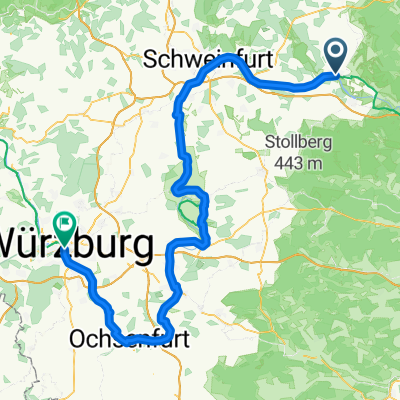
Hassfurt, Handthal, GEO, Hassfurt
A cycling route starting in Haßfurt, Bavaria, Germany.
Overview
About this route
- -:--
- Duration
- 52.7 km
- Distance
- 845 m
- Ascent
- 845 m
- Descent
- ---
- Avg. speed
- ---
- Max. altitude
Route highlights
Points of interest along the route
Point of interest after 0 km
Hotel Bär, Pfarrgasse 2
Point of interest after 13.8 km
Zabelstein, Ausichtsturm; Sonderprüfung
Point of interest after 18.8 km
Panoramablick
Point of interest after 27.5 km
Ruine Stollberg
Point of interest after 29 km
Biergarten, Cafe; Bernd Lust
Point of interest after 30 km
Aufstieg im "Bärlauchtal"
Point of interest after 30.6 km
Steinernes Kreuz
Point of interest after 37 km
Grasberg (433)
Continue with Bikemap
Use, edit, or download this cycling route
You would like to ride Hassfurt, Handthal, GEO, Hassfurt or customize it for your own trip? Here is what you can do with this Bikemap route:
Free features
- Save this route as favorite or in collections
- Copy & plan your own version of this route
- Sync your route with Garmin or Wahoo
Premium features
Free trial for 3 days, or one-time payment. More about Bikemap Premium.
- Navigate this route on iOS & Android
- Export a GPX / KML file of this route
- Create your custom printout (try it for free)
- Download this route for offline navigation
Discover more Premium features.
Get Bikemap PremiumFrom our community
Other popular routes starting in Haßfurt
 6. Tag Haßfurt-Bad Bocklet
- Distance
- 63 km
- Ascent
- 314 m
- Descent
- 318 m
- Location
- Haßfurt, Bavaria, Germany
 2015_Berlin - Büttikon_009
- Distance
- 106.6 km
- Ascent
- 192 m
- Descent
- 111 m
- Location
- Haßfurt, Bavaria, Germany
 Maroldsweisach 170520
- Distance
- 47.4 km
- Ascent
- 464 m
- Descent
- 436 m
- Location
- Haßfurt, Bavaria, Germany
 Haßfurt-Bamberg
- Distance
- 36.2 km
- Ascent
- 132 m
- Descent
- 119 m
- Location
- Haßfurt, Bavaria, Germany
 Bergrheinfeld - Wurzburg
- Distance
- 111.1 km
- Ascent
- 386 m
- Descent
- 443 m
- Location
- Haßfurt, Bavaria, Germany
 Von Königsberg in den Steigerwald
- Distance
- 43 km
- Ascent
- 490 m
- Descent
- 490 m
- Location
- Haßfurt, Bavaria, Germany
 Route Hassfurt Hummelhof
- Distance
- 18.9 km
- Ascent
- 253 m
- Descent
- 140 m
- Location
- Haßfurt, Bavaria, Germany
 Königsberg in Bayern (40,3 km)
- Distance
- 42.2 km
- Ascent
- 617 m
- Descent
- 618 m
- Location
- Haßfurt, Bavaria, Germany
Open it in the app