
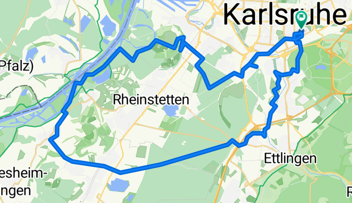
KA - Durlach - Durmersheim - Au am Rhein - KA
A cycling route starting in Karlsruhe, Baden-Württemberg, Germany.
Overview
About this route
- -:--
- Duration
- 44.5 km
- Distance
- 84 m
- Ascent
- 82 m
- Descent
- ---
- Avg. speed
- 126 m
- Avg. speed
Route quality
Waytypes & surfaces along the route
Waytypes
Track
13.3 km
(30 %)
Path
9.6 km
(22 %)
Surfaces
Paved
27.6 km
(62 %)
Unpaved
15.2 km
(34 %)
Asphalt
24.2 km
(54 %)
Gravel
7.2 km
(16 %)
Route highlights
Points of interest along the route
Point of interest after 40.2 km
Güterzug blockierte Bahnübergang -> retoure!
Continue with Bikemap
Use, edit, or download this cycling route
You would like to ride KA - Durlach - Durmersheim - Au am Rhein - KA or customize it for your own trip? Here is what you can do with this Bikemap route:
Free features
- Save this route as favorite or in collections
- Copy & plan your own version of this route
- Sync your route with Garmin or Wahoo
Premium features
Free trial for 3 days, or one-time payment. More about Bikemap Premium.
- Navigate this route on iOS & Android
- Export a GPX / KML file of this route
- Create your custom printout (try it for free)
- Download this route for offline navigation
Discover more Premium features.
Get Bikemap PremiumFrom our community
Other popular routes starting in Karlsruhe
 n bisschen Schwarzwald
- Distance
- 55.4 km
- Ascent
- 670 m
- Descent
- 656 m
- Location
- Karlsruhe, Baden-Württemberg, Germany
 Kleine Feierabendrunde
- Distance
- 24.3 km
- Ascent
- 99 m
- Descent
- 100 m
- Location
- Karlsruhe, Baden-Württemberg, Germany
 Durlach-Pfinztal Runde
- Distance
- 39.3 km
- Ascent
- 413 m
- Descent
- 406 m
- Location
- Karlsruhe, Baden-Württemberg, Germany
 KA - Durlach - Wattkopf - Muschelbach - Thomashof - KA
- Distance
- 48.9 km
- Ascent
- 656 m
- Descent
- 654 m
- Location
- Karlsruhe, Baden-Württemberg, Germany
 kleine Rheinhafenrunde (ab/bis Nottingham Anlage, Karlsruhe)
- Distance
- 22.1 km
- Ascent
- 25 m
- Descent
- 30 m
- Location
- Karlsruhe, Baden-Württemberg, Germany
 durch die Vorderpfalz
- Distance
- 69.7 km
- Ascent
- 141 m
- Descent
- 150 m
- Location
- Karlsruhe, Baden-Württemberg, Germany
 KA: Abendlicher Rundkurs +/- 1h 15min
- Distance
- 30.5 km
- Ascent
- 51 m
- Descent
- 49 m
- Location
- Karlsruhe, Baden-Württemberg, Germany
 Karlsruhe - Turmberg - Stupferich - Mutschelbach - Langensteinbach - Ittersbach - Schöllbronn - Ettlingen - Karlsruhe
- Distance
- 59 km
- Ascent
- 514 m
- Descent
- 515 m
- Location
- Karlsruhe, Baden-Württemberg, Germany
Open it in the app