

Zwischen Himmel und Hölle (-berg)
A cycling route starting in Bad Karlshafen, Lower Saxony, Germany.
Overview
About this route
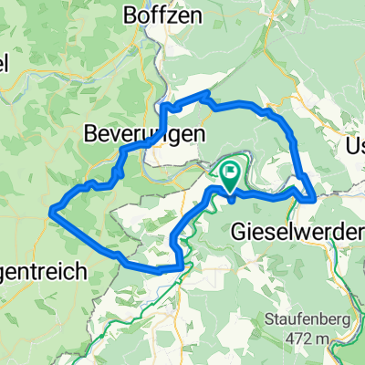
A beautiful tour of nearly 29km with approximately 500 meters of elevation. The tour starts in Bad Karlshafen at the Hafenplatz and provides us with first impressions of the wild romantic Reinhardswald. A tour with many beautiful views: Hessenkanzel, Hölleberg, Krukenburg, or Hugenottenturm offer the opportunity to catch a glimpse of the region and the route from above. Beautiful single trail sections, challenging climbs, dreamy panoramic views, and the realization that alongside splendid natural impressions spiced with a pinch of cultural history, about 1100 kcal will also be burned.Refreshment options: numerous in Bad Karlshafen, Forellenzucht Dworak in Wülmersen, Don Pepe's Kornhauscafe in Haarbrück, Erlenhofcafe (Herstelle), Cafe zur Krukenburg.Asphalt Gravel Singletrail approx.12.0 km 14 km 2.4 km Start: The loop starts at the Hafenplatz in front of the museum
Duration: approx. 2h
detailed description:
- -:--
- Duration
- 28.6 km
- Distance
- 471 m
- Ascent
- 471 m
- Descent
- ---
- Avg. speed
- ---
- Max. altitude
Route quality
Waytypes & surfaces along the route
Waytypes
Track
20.1 km
(70 %)
Quiet road
4.6 km
(16 %)
Surfaces
Paved
14.9 km
(52 %)
Unpaved
12 km
(42 %)
Asphalt
12.6 km
(44 %)
Gravel
9.5 km
(33 %)
Continue with Bikemap
Use, edit, or download this cycling route
You would like to ride Zwischen Himmel und Hölle (-berg) or customize it for your own trip? Here is what you can do with this Bikemap route:
Free features
- Save this route as favorite or in collections
- Copy & plan your own version of this route
- Sync your route with Garmin or Wahoo
Premium features
Free trial for 3 days, or one-time payment. More about Bikemap Premium.
- Navigate this route on iOS & Android
- Export a GPX / KML file of this route
- Create your custom printout (try it for free)
- Download this route for offline navigation
Discover more Premium features.
Get Bikemap PremiumFrom our community
Other popular routes starting in Bad Karlshafen
 Bad Karlshafen - Höxter
- Distance
- 25.3 km
- Ascent
- 216 m
- Descent
- 216 m
- Location
- Bad Karlshafen, Lower Saxony, Germany
 Feierabendrunde mit Spaßfaktor
- Distance
- 18 km
- Ascent
- 374 m
- Descent
- 365 m
- Location
- Bad Karlshafen, Lower Saxony, Germany
 9KarlshafenHannMB
- Distance
- 51.1 km
- Ascent
- 338 m
- Descent
- 301 m
- Location
- Bad Karlshafen, Lower Saxony, Germany
 Trendelburg, Jakobsberg, Derental, Bodenfelde
- Distance
- 65.7 km
- Ascent
- 788 m
- Descent
- 787 m
- Location
- Bad Karlshafen, Lower Saxony, Germany
 tuor 2
- Distance
- 83.4 km
- Ascent
- 339 m
- Descent
- 370 m
- Location
- Bad Karlshafen, Lower Saxony, Germany
 Der Weserradweg
- Distance
- 396.9 km
- Ascent
- 82 m
- Descent
- 181 m
- Location
- Bad Karlshafen, Lower Saxony, Germany
 Gipfeltour im Reinhardswald
- Distance
- 58.9 km
- Ascent
- 917 m
- Descent
- 920 m
- Location
- Bad Karlshafen, Lower Saxony, Germany
 An der Schlagd 3, Карлсхафен до An der Schlagd 3, Карлсхафен
- Distance
- 53.1 km
- Ascent
- 930 m
- Descent
- 931 m
- Location
- Bad Karlshafen, Lower Saxony, Germany
Open it in the app