

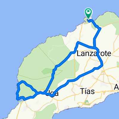
Tinajo-Haria-Orzola-CostaTeguise
A cycling route starting in Tinajo, Canary Islands, Spain.
Overview
About this route
Moving day ending in Costa Teguise... we will leave Tinajo heading towards the surfer and fishing village La Santa and Famara... passing the La Santa sports residential complex... we will climb to the beautiful village of Teguise, where we will not stop climbing until we reach the viewpoint of Los Helechos in the Valleys, going down towards Haría, passing through the center of the village of Haría and passing through its square we would reach the ascent to Maguez, after a short descent we will begin the climb to Mirador del Rio, after this we will go down towards the village of Orzola (where on a touristic day you would take the ferry to the island of La Graciosa, advisable to go, but with MTB bikes), after Orzola and getting to know its port, we will cover the entire coast passing by Jameos del Agua, and once we pass the villages where you can taste in their restaurants like 'el amanecer' the good fish from the island, we will take the cyclist road after Guatiza where we will reach our destination of Costa Teguise.
- -:--
- Duration
- 101.3 km
- Distance
- 0 m
- Ascent
- 0 m
- Descent
- ---
- Avg. speed
- 0 m
- Max. altitude

Route quality
Waytypes & surfaces along the route
Waytypes
Cycleway
11.1 km
(11 %)
Quiet road
10.1 km
(10 %)
Surfaces
Paved
80 km
(79 %)
Unpaved
10.1 km
(10 %)
Asphalt
80 km
(79 %)
Gravel
5.1 km
(5 %)
Continue with Bikemap
Use, edit, or download this cycling route
You would like to ride Tinajo-Haria-Orzola-CostaTeguise or customize it for your own trip? Here is what you can do with this Bikemap route:
Free features
- Save this route as favorite or in collections
- Copy & plan your own version of this route
- Split it into stages to create a multi-day tour
- Sync your route with Garmin or Wahoo
Premium features
Free trial for 3 days, or one-time payment. More about Bikemap Premium.
- Navigate this route on iOS & Android
- Export a GPX / KML file of this route
- Create your custom printout (try it for free)
- Download this route for offline navigation
Discover more Premium features.
Get Bikemap PremiumFrom our community
Other popular routes starting in Tinajo
 Feuer lang 59
- Distance
- 59.7 km
- Ascent
- 879 m
- Descent
- 880 m
- Location
- Tinajo, Canary Islands, Spain
 La Santa - El Golfo
- Distance
- 70.1 km
- Ascent
- 770 m
- Descent
- 763 m
- Location
- Tinajo, Canary Islands, Spain
 Kanári szigetek 3. nap
- Distance
- 103 km
- Ascent
- 926 m
- Descent
- 912 m
- Location
- Tinajo, Canary Islands, Spain
 Conil Trip - Distance 50km
- Distance
- 52.2 km
- Ascent
- 415 m
- Descent
- 415 m
- Location
- Tinajo, Canary Islands, Spain
 Tabayesco 85km
- Distance
- 85.2 km
- Ascent
- 1,381 m
- Descent
- 1,383 m
- Location
- Tinajo, Canary Islands, Spain
 Kanári szigetek 4. nap
- Distance
- 90.4 km
- Ascent
- 706 m
- Descent
- 626 m
- Location
- Tinajo, Canary Islands, Spain
 Mirador del Rio 112k
- Distance
- 111.7 km
- Ascent
- 1,739 m
- Descent
- 1,739 m
- Location
- Tinajo, Canary Islands, Spain
 La Santa to El Golfo
- Distance
- 84 km
- Ascent
- 765 m
- Descent
- 764 m
- Location
- Tinajo, Canary Islands, Spain
Open it in the app