

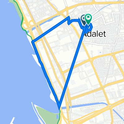
From home to Karşıyaka İskele
A cycling route starting in Bayraklı, İzmir Province, Republic of Türkiye.
Overview
About this route
- 23 min
- Duration
- 4.5 km
- Distance
- 58 m
- Ascent
- 62 m
- Descent
- 11.5 km/h
- Avg. speed
- 4 m
- Max. altitude

Route quality
Waytypes & surfaces along the route
Waytypes
Quiet road
2 km
(45 %)
Road
0.1 km
(3 %)
Undefined
2.3 km
(52 %)
Continue with Bikemap
Use, edit, or download this cycling route
You would like to ride From home to Karşıyaka İskele or customize it for your own trip? Here is what you can do with this Bikemap route:
Free features
- Save this route as favorite or in collections
- Copy & plan your own version of this route
- Sync your route with Garmin or Wahoo
Premium features
Free trial for 3 days, or one-time payment. More about Bikemap Premium.
- Navigate this route on iOS & Android
- Export a GPX / KML file of this route
- Create your custom printout (try it for free)
- Download this route for offline navigation
Discover more Premium features.
Get Bikemap PremiumFrom our community
Other popular routes starting in Bayraklı
 2109. Sk. 114, Bayrakli to Mithatpasa Cd. 56/01, Balcova
- Distance
- 22.2 km
- Ascent
- 86 m
- Descent
- 120 m
- Location
- Bayraklı, İzmir Province, Republic of Türkiye
 Kuş cenneti yolunda
- Distance
- 51 km
- Ascent
- 147 m
- Descent
- 158 m
- Location
- Bayraklı, İzmir Province, Republic of Türkiye
 1586/16. Sokak 9/a to 2132/2 Sokak 13
- Distance
- 4.5 km
- Ascent
- 9 m
- Descent
- 11 m
- Location
- Bayraklı, İzmir Province, Republic of Türkiye
 Bayraklı-a short trip
- Distance
- 12.5 km
- Ascent
- 188 m
- Descent
- 142 m
- Location
- Bayraklı, İzmir Province, Republic of Türkiye
 Yerebatan Caddesi to Civcili Ahmet Ağa Meydanı
- Distance
- 507.9 km
- Ascent
- 5,639 m
- Descent
- 5,638 m
- Location
- Bayraklı, İzmir Province, Republic of Türkiye
 salhane ist. - bornova - kayadibi - karagöl - karşıyaka
- Distance
- 54 km
- Ascent
- 1,106 m
- Descent
- 1,095 m
- Location
- Bayraklı, İzmir Province, Republic of Türkiye
 BORNOVA-EĞRİDERE-YAMANLAR DAĞI ZİRVE (ANTENLER)
- Distance
- 47.7 km
- Ascent
- 1,379 m
- Descent
- 1,378 m
- Location
- Bayraklı, İzmir Province, Republic of Türkiye
 İzmir - Manisa Üçpınar - Menemen - İzmir
- Distance
- 117.7 km
- Ascent
- 730 m
- Descent
- 730 m
- Location
- Bayraklı, İzmir Province, Republic of Türkiye
Open it in the app