

2-Länder-Runde
A cycling route starting in Sigmarszell, Bavaria, Germany.
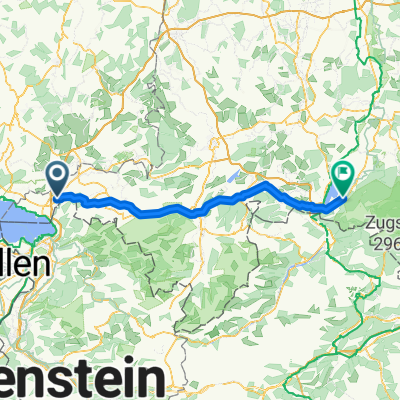
Overview
About this route
After a short warm-up, a moderate to steep ascent on an unpaved path. Then hilly terrain on asphalt. Nice technical descent over gravel and unpaved paths. Flat finish with a short climb on asphalt.
- -:--
- Duration
- 21.4 km
- Distance
- 569 m
- Ascent
- 569 m
- Descent
- ---
- Avg. speed
- ---
- Max. altitude
Continue with Bikemap
Use, edit, or download this cycling route
You would like to ride 2-Länder-Runde or customize it for your own trip? Here is what you can do with this Bikemap route:
Free features
- Save this route as favorite or in collections
- Copy & plan your own version of this route
- Sync your route with Garmin or Wahoo
Premium features
Free trial for 3 days, or one-time payment. More about Bikemap Premium.
- Navigate this route on iOS & Android
- Export a GPX / KML file of this route
- Create your custom printout (try it for free)
- Download this route for offline navigation
Discover more Premium features.
Get Bikemap PremiumFrom our community
Other popular routes starting in Sigmarszell
 hoenweiler - neuravensbuersee - amtzell - degersee - h.
- Distance
- 52.5 km
- Ascent
- 358 m
- Descent
- 360 m
- Location
- Sigmarszell, Bavaria, Germany
 Mollenberg 25, Hergensweiler nach Grasbeurer Straße 3, Uhldingen-Mühlhofen
- Distance
- 50 km
- Ascent
- 383 m
- Descent
- 506 m
- Location
- Sigmarszell, Bavaria, Germany
 Von Sigmarszell zum Bannwaldsee
- Distance
- 97.4 km
- Ascent
- 994 m
- Descent
- 712 m
- Location
- Sigmarszell, Bavaria, Germany
 Oberallgäurunde
- Distance
- 145.9 km
- Ascent
- 1,645 m
- Descent
- 1,645 m
- Location
- Sigmarszell, Bavaria, Germany
 Oberallgäurunde
- Distance
- 121.4 km
- Ascent
- 1,671 m
- Descent
- 1,671 m
- Location
- Sigmarszell, Bavaria, Germany
 Von Sigmarszell zum Bannwaldsee
- Distance
- 95.3 km
- Ascent
- 1,518 m
- Descent
- 1,231 m
- Location
- Sigmarszell, Bavaria, Germany
 Sigmarszell-Pfänder-Bregenz-zurück
- Distance
- 71.3 km
- Ascent
- 1,008 m
- Descent
- 1,008 m
- Location
- Sigmarszell, Bavaria, Germany
 hohenweiler - lindenberg - pfänder
- Distance
- 46.8 km
- Ascent
- 836 m
- Descent
- 685 m
- Location
- Sigmarszell, Bavaria, Germany
Open it in the app