

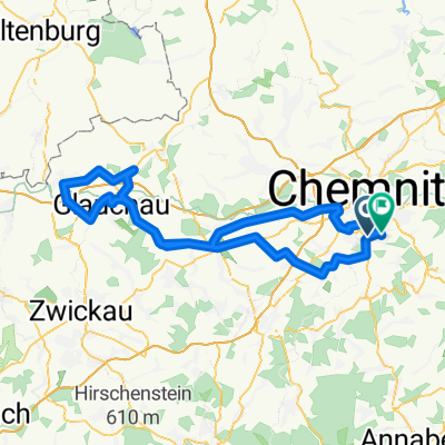
Harthau-Weißbach-Burkhardtsdorf-Harthau
A cycling route starting in Neukirchen, Saxony, Germany.
Overview
About this route
Kurze Runde mit genügend Höhenmetern.
- -:--
- Duration
- 30.6 km
- Distance
- 529 m
- Ascent
- 437 m
- Descent
- ---
- Avg. speed
- 577 m
- Max. altitude

Route quality
Waytypes & surfaces along the route
Waytypes
Track
16.2 km
(53 %)
Quiet road
6.9 km
(23 %)
Surfaces
Paved
15.6 km
(51 %)
Unpaved
11.7 km
(38 %)
Asphalt
13.9 km
(45 %)
Gravel
3.6 km
(12 %)
Continue with Bikemap
Use, edit, or download this cycling route
You would like to ride Harthau-Weißbach-Burkhardtsdorf-Harthau or customize it for your own trip? Here is what you can do with this Bikemap route:
Free features
- Save this route as favorite or in collections
- Copy & plan your own version of this route
- Sync your route with Garmin or Wahoo
Premium features
Free trial for 3 days, or one-time payment. More about Bikemap Premium.
- Navigate this route on iOS & Android
- Export a GPX / KML file of this route
- Create your custom printout (try it for free)
- Download this route for offline navigation
Discover more Premium features.
Get Bikemap PremiumFrom our community
Other popular routes starting in Neukirchen
 Zwönitz
- Distance
- 52.3 km
- Ascent
- 727 m
- Descent
- 723 m
- Location
- Neukirchen, Saxony, Germany
 ADFC Feierabend
- Distance
- 27.5 km
- Ascent
- 286 m
- Descent
- 270 m
- Location
- Neukirchen, Saxony, Germany
 Vom Chemnitzer Westen über Küchwald /Glößa zurück durch den Stadtpark
- Distance
- 55.2 km
- Ascent
- 375 m
- Descent
- 377 m
- Location
- Neukirchen, Saxony, Germany
 500 Hm Trainingsrunde
- Distance
- 36.6 km
- Ascent
- 595 m
- Descent
- 595 m
- Location
- Neukirchen, Saxony, Germany
 Oberwald Hohenstein querdurch
- Distance
- 42.8 km
- Ascent
- 430 m
- Descent
- 433 m
- Location
- Neukirchen, Saxony, Germany
 Chemnitz - Südböhmen - Südmähren
- Distance
- 844.3 km
- Ascent
- 2,001 m
- Descent
- 2,130 m
- Location
- Neukirchen, Saxony, Germany
 RR Tour Meerane
- Distance
- 99.6 km
- Ascent
- 423 m
- Descent
- 388 m
- Location
- Neukirchen, Saxony, Germany
 Erzgebirgstour
- Distance
- 96.5 km
- Ascent
- 1,517 m
- Descent
- 1,494 m
- Location
- Neukirchen, Saxony, Germany
Open it in the app