

Szlak zielony gminy Garbów
A cycling route starting in Garbów, Lublin Voivodeship, Poland.
Overview
About this route
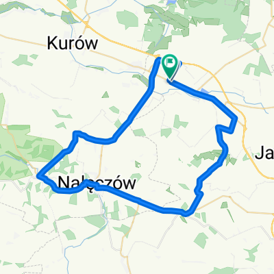
Szlak rowerowy zielony po południowej części gminy Garbów
- -:--
- Duration
- 16.1 km
- Distance
- 120 m
- Ascent
- 119 m
- Descent
- ---
- Avg. speed
- 222 m
- Max. altitude
Route quality
Waytypes & surfaces along the route
Waytypes
Quiet road
12.4 km
(77 %)
Road
3.5 km
(22 %)
Surfaces
Paved
15.8 km
(98 %)
Asphalt
15.8 km
(98 %)
Undefined
0.3 km
(2 %)
Continue with Bikemap
Use, edit, or download this cycling route
You would like to ride Szlak zielony gminy Garbów or customize it for your own trip? Here is what you can do with this Bikemap route:
Free features
- Save this route as favorite or in collections
- Copy & plan your own version of this route
- Sync your route with Garmin or Wahoo
Premium features
Free trial for 3 days, or one-time payment. More about Bikemap Premium.
- Navigate this route on iOS & Android
- Export a GPX / KML file of this route
- Create your custom printout (try it for free)
- Download this route for offline navigation
Discover more Premium features.
Get Bikemap PremiumFrom our community
Other popular routes starting in Garbów
 Lubelska, Zagrody do Lubelska, Zagrody
- Distance
- 50.2 km
- Ascent
- 349 m
- Descent
- 353 m
- Location
- Garbów, Lublin Voivodeship, Poland
 łącznik Samoklęski Kol. II – Meszno (żółty)
- Distance
- 7.1 km
- Ascent
- 17 m
- Descent
- 29 m
- Location
- Garbów, Lublin Voivodeship, Poland
 Szlak zielony gminy Garbów
- Distance
- 16.1 km
- Ascent
- 120 m
- Descent
- 119 m
- Location
- Garbów, Lublin Voivodeship, Poland
 szlak po gm. Garbów – łącznik Garbów – Garbów (czerwony)
- Distance
- 3.2 km
- Ascent
- 32 m
- Descent
- 22 m
- Location
- Garbów, Lublin Voivodeship, Poland
 Cisowa 11, Zagrody do Cisowa 11, Zagrody
- Distance
- 31.9 km
- Ascent
- 206 m
- Descent
- 204 m
- Location
- Garbów, Lublin Voivodeship, Poland
 łącznik Leśce - Piotrowice-Kolonia (żółty)
- Distance
- 1.9 km
- Ascent
- 4 m
- Descent
- 4 m
- Location
- Garbów, Lublin Voivodeship, Poland
 Moszna-Kolonia 53, Jastków do Moszna-Kolonia 53, Jastków
- Distance
- 13.9 km
- Ascent
- 65 m
- Descent
- 67 m
- Location
- Garbów, Lublin Voivodeship, Poland
 (szlaki.lu) Szlak CZARNY (Gmina Garbów)
- Distance
- 33.3 km
- Ascent
- 106 m
- Descent
- 107 m
- Location
- Garbów, Lublin Voivodeship, Poland
Open it in the app