

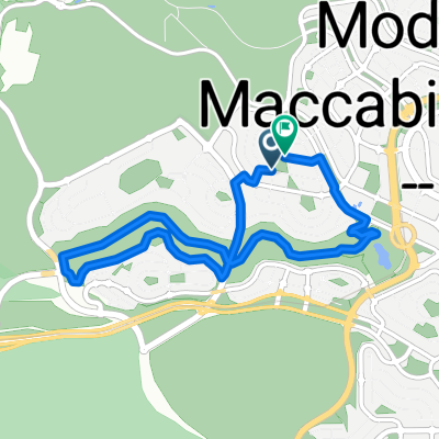
נופים||מרכז מודיעין||אזור ליגד ופארק מים
A cycling route starting in Modiin, Central District, Israel.
Overview
About this route
- 1 h 36 min
- Duration
- 35 km
- Distance
- 164 m
- Ascent
- 206 m
- Descent
- 21.8 km/h
- Avg. speed
- 291 m
- Max. altitude

Continue with Bikemap
Use, edit, or download this cycling route
You would like to ride נופים||מרכז מודיעין||אזור ליגד ופארק מים or customize it for your own trip? Here is what you can do with this Bikemap route:
Free features
- Save this route as favorite or in collections
- Copy & plan your own version of this route
- Sync your route with Garmin or Wahoo
Premium features
Free trial for 3 days, or one-time payment. More about Bikemap Premium.
- Navigate this route on iOS & Android
- Export a GPX / KML file of this route
- Create your custom printout (try it for free)
- Download this route for offline navigation
Discover more Premium features.
Get Bikemap PremiumFrom our community
Other popular routes starting in Modiin
 מסלול 1
- Distance
- 30.8 km
- Ascent
- 497 m
- Descent
- 487 m
- Location
- Modiin, Central District, Israel
 בעיקר כביש 27
- Distance
- 27 km
- Ascent
- 322 m
- Descent
- 322 m
- Location
- Modiin, Central District, Israel
 Migdal Yam Street, Modi'in-Makkabbim-Re'ut to Bedolach Street, Modi'in-Makkabbim-Re'ut
- Distance
- 7.8 km
- Ascent
- 98 m
- Descent
- 101 m
- Location
- Modiin, Central District, Israel
 נופים||מרכז מודיעין||אזור ליגד ופארק מים
- Distance
- 35 km
- Ascent
- 164 m
- Descent
- 206 m
- Location
- Modiin, Central District, Israel
 Bedolach Street, Modi'in-Makkabbim-Re'ut to Bedolach Street, Modi'in-Makkabbim-Re'ut
- Distance
- 8.1 km
- Ascent
- 109 m
- Descent
- 110 m
- Location
- Modiin, Central District, Israel
 YamDay_newD2.1 - YamDay_newD2.1
- Distance
- 120.7 km
- Ascent
- 1,894 m
- Descent
- 1,894 m
- Location
- Modiin, Central District, Israel
 ריצה: מודיעין 1
- Distance
- 16.7 km
- Ascent
- 193 m
- Descent
- 193 m
- Location
- Modiin, Central District, Israel
 יער לחי, קיבוץ גזר
- Distance
- 13.4 km
- Ascent
- 134 m
- Descent
- 137 m
- Location
- Modiin, Central District, Israel
Open it in the app