

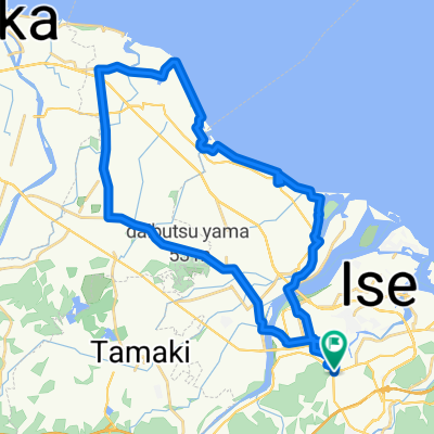
小俣町明野721-2, 伊勢市 to 石津町104-8, 松阪市
A cycling route starting in Ise, Mie, Japan.
Overview
About this route
- 1 h 26 min
- Duration
- 20.8 km
- Distance
- 74 m
- Ascent
- 78 m
- Descent
- 14.5 km/h
- Avg. speed
- 18 m
- Max. altitude
Route quality
Waytypes & surfaces along the route
Waytypes
Quiet road
13.4 km
(64 %)
Busy road
4.3 km
(21 %)
Surfaces
Paved
7.6 km
(36 %)
Paved (undefined)
7.6 km
(36 %)
Undefined
13.2 km
(64 %)
Continue with Bikemap
Use, edit, or download this cycling route
You would like to ride 小俣町明野721-2, 伊勢市 to 石津町104-8, 松阪市 or customize it for your own trip? Here is what you can do with this Bikemap route:
Free features
- Save this route as favorite or in collections
- Copy & plan your own version of this route
- Sync your route with Garmin or Wahoo
Premium features
Free trial for 3 days, or one-time payment. More about Bikemap Premium.
- Navigate this route on iOS & Android
- Export a GPX / KML file of this route
- Create your custom printout (try it for free)
- Download this route for offline navigation
Discover more Premium features.
Get Bikemap PremiumFrom our community
Other popular routes starting in Ise
 吹上1丁目, 伊勢市へ桜木町, 伊勢市
- Distance
- 6 km
- Ascent
- 214 m
- Descent
- 199 m
- Location
- Ise, Mie, Japan
 Ise Sea to Summitish (ca. 55k)
- Distance
- 58.3 km
- Ascent
- 184 m
- Descent
- 184 m
- Location
- Ise, Mie, Japan
 Aeon Circular
- Distance
- 38.2 km
- Ascent
- 26 m
- Descent
- 23 m
- Location
- Ise, Mie, Japan
 Japan: Ise-Mountains 2
- Distance
- 35.9 km
- Ascent
- 412 m
- Descent
- 412 m
- Location
- Ise, Mie, Japan
 水と禊の斎宮を巡るコース
- Distance
- 21.1 km
- Ascent
- 21 m
- Descent
- 22 m
- Location
- Ise, Mie, Japan
 南勢バイパス, 伊勢市 to 伊勢市
- Distance
- 105.4 km
- Ascent
- 2,306 m
- Descent
- 2,302 m
- Location
- Ise, Mie, Japan
 Day 601-1
- Distance
- 19 km
- Ascent
- 107 m
- Descent
- 108 m
- Location
- Ise, Mie, Japan
 Trans Kii Peninsula (from Ise to Yoshino)
- Distance
- 107.9 km
- Ascent
- 1,024 m
- Descent
- 863 m
- Location
- Ise, Mie, Japan
Open it in the app