
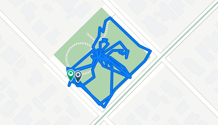
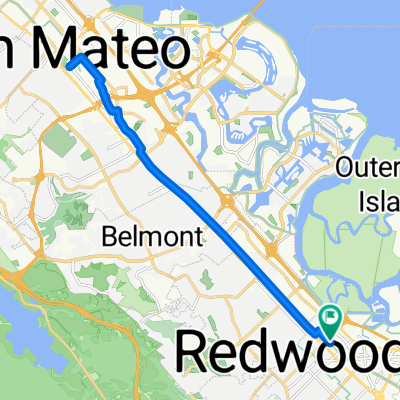
73–99 Lowell St, Redwood City to Eagle Hill, Redwood City
A cycling route starting in Redwood City, California, United States.
Overview
About this route
- 1 h 4 min
- Duration
- 1.1 km
- Distance
- 25 m
- Ascent
- 28 m
- Descent
- 1.1 km/h
- Avg. speed
- 19 m
- Max. altitude

Continue with Bikemap
Use, edit, or download this cycling route
You would like to ride 73–99 Lowell St, Redwood City to Eagle Hill, Redwood City or customize it for your own trip? Here is what you can do with this Bikemap route:
Free features
- Save this route as favorite or in collections
- Copy & plan your own version of this route
- Sync your route with Garmin or Wahoo
Premium features
Free trial for 3 days, or one-time payment. More about Bikemap Premium.
- Navigate this route on iOS & Android
- Export a GPX / KML file of this route
- Create your custom printout (try it for free)
- Download this route for offline navigation
Discover more Premium features.
Get Bikemap PremiumFrom our community
Other popular routes starting in Redwood City
 Fay Street 1181, Redwood City to Fay Street 1190, Redwood City
- Distance
- 18.9 km
- Ascent
- 85 m
- Descent
- 84 m
- Location
- Redwood City, California, United States
 61 mile tour de peace
- Distance
- 99.4 km
- Ascent
- 812 m
- Descent
- 812 m
- Location
- Redwood City, California, United States
 Peninsula Bikeway South
- Distance
- 23.3 km
- Ascent
- 16 m
- Descent
- 14 m
- Location
- Redwood City, California, United States
 Seems like a nice route, haven't tried it
- Distance
- 17.5 km
- Ascent
- 223 m
- Descent
- 224 m
- Location
- Redwood City, California, United States
 Redwood City to Pescadero to Tunitas Creek Loop
- Distance
- 92.2 km
- Ascent
- 1,597 m
- Descent
- 1,597 m
- Location
- Redwood City, California, United States
 RWC Atherton Menlo Loop 15mi
- Distance
- 24.5 km
- Ascent
- 55 m
- Descent
- 57 m
- Location
- Redwood City, California, United States
 Sunday bike ride
- Distance
- 41.1 km
- Ascent
- 402 m
- Descent
- 351 m
- Location
- Redwood City, California, United States
 70 mile tour de peace
- Distance
- 114 km
- Ascent
- 1,325 m
- Descent
- 1,325 m
- Location
- Redwood City, California, United States
Open it in the app