

Wyprawa 2024 - Dzień 2
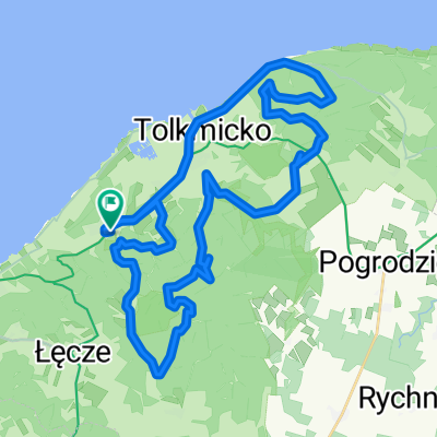
A cycling route starting in Tolkmicko, Warmian-Masurian Voivodeship, Poland.
Overview
About this route
- -:--
- Duration
- 139.8 km
- Distance
- 799 m
- Ascent
- 730 m
- Descent
- ---
- Avg. speed
- 177 m
- Max. altitude

Route quality
Waytypes & surfaces along the route
Waytypes
Quiet road
67.9 km
(49 %)
Track
24.9 km
(18 %)
Surfaces
Paved
78.2 km
(56 %)
Unpaved
40.8 km
(29 %)
Asphalt
57.5 km
(41 %)
Gravel
37.4 km
(27 %)
Route highlights
Points of interest along the route
Point of interest after 18.4 km
Wieża Kopernika
Point of interest after 18.4 km
Wieża Radziejowskiego
Point of interest after 18.5 km
Wieża Wodna we Fromborku
Point of interest after 18.6 km
Katedra we Fromborku
Point of interest after 18.6 km
Muzeum Mikołaja Kopernika
Point of interest after 37.7 km
Ruiny zamku w Braniewie
Point of interest after 77.5 km
Ruiny zamku Kapituły Warmińskiej w Pieniężnie
Continue with Bikemap
Use, edit, or download this cycling route
You would like to ride Wyprawa 2024 - Dzień 2 or customize it for your own trip? Here is what you can do with this Bikemap route:
Free features
- Save this route as favorite or in collections
- Copy & plan your own version of this route
- Split it into stages to create a multi-day tour
- Sync your route with Garmin or Wahoo
Premium features
Free trial for 3 days, or one-time payment. More about Bikemap Premium.
- Navigate this route on iOS & Android
- Export a GPX / KML file of this route
- Create your custom printout (try it for free)
- Download this route for offline navigation
Discover more Premium features.
Get Bikemap PremiumFrom our community
Other popular routes starting in Tolkmicko
 MTB Kadyny CLONED FROM ROUTE 662734
- Distance
- 37.8 km
- Ascent
- 463 m
- Descent
- 463 m
- Location
- Tolkmicko, Warmian-Masurian Voivodeship, Poland
 Lengthy bike tour from Pastviny to Tolkmicko
- Distance
- 35.3 km
- Ascent
- 238 m
- Descent
- 238 m
- Location
- Tolkmicko, Warmian-Masurian Voivodeship, Poland
 MTB Kadyny
- Distance
- 37.8 km
- Ascent
- 463 m
- Descent
- 463 m
- Location
- Tolkmicko, Warmian-Masurian Voivodeship, Poland
 ŁĘCZE EVERESTING 2017
- Distance
- 9.3 km
- Ascent
- 156 m
- Descent
- 156 m
- Location
- Tolkmicko, Warmian-Masurian Voivodeship, Poland
 Wyjazd nad morze - etap 17
- Distance
- 106.4 km
- Ascent
- 397 m
- Descent
- 263 m
- Location
- Tolkmicko, Warmian-Masurian Voivodeship, Poland
 Suchacz-Rubno- Smoki-Tolkmicko-Suchacz
- Distance
- 38.5 km
- Ascent
- 358 m
- Descent
- 359 m
- Location
- Tolkmicko, Warmian-Masurian Voivodeship, Poland
 Z Jackiem
- Distance
- 62 km
- Ascent
- 599 m
- Descent
- 604 m
- Location
- Tolkmicko, Warmian-Masurian Voivodeship, Poland
 Dookoła Mazur dzień 6
- Distance
- 83.1 km
- Ascent
- 133 m
- Descent
- 130 m
- Location
- Tolkmicko, Warmian-Masurian Voivodeship, Poland
Open it in the app