
Cyclocross ab Niefern
A cycling route starting in Niefern-Öschelbronn, Baden-Wurttemberg, Germany.
Overview
About this route
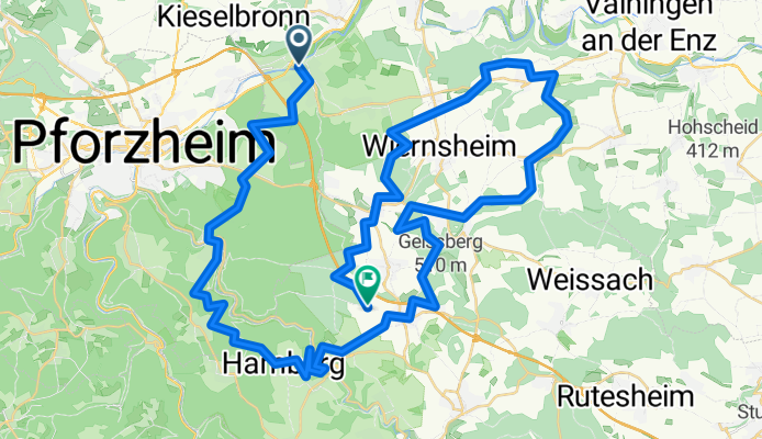
The meeting point for this round was Niefern. Through Hagenschieß down into the Würmtal and up the other side. Passing through Tiefenbronn, Friolzheim, past Mönsheim, above the Grenzbachhof to Iptingen with a short trail. Continuing up the slope to Großglattbach (wow! 17%). Then via field paths to Pinache, later on forest paths to Wurmberg. Through the forest to the roundabout before Friolzheim. Aside from some short steep sections, the terrain is easy. The surface ranges from unpaved to gravel and asphalt. Not suitable for road bikes. Easy for MTB. Ideal for Cyclocross.
- -:--
- Duration
- 65.3 km
- Distance
- 1,227 m
- Ascent
- 1,008 m
- Descent
- ---
- Avg. speed
- 525 m
- Max. altitude

Route quality
Waytypes & surfaces along the route
Waytypes
Track
45.7 km
(70 %)
Quiet road
7.8 km
(12 %)
Surfaces
Paved
30 km
(46 %)
Unpaved
31.3 km
(48 %)
Gravel
22.2 km
(34 %)
Asphalt
20.9 km
(32 %)
Continue with Bikemap
Use, edit, or download this cycling route
You would like to ride Cyclocross ab Niefern or customize it for your own trip? Here is what you can do with this Bikemap route:
Free features
- Save this route as favorite or in collections
- Copy & plan your own version of this route
- Sync your route with Garmin or Wahoo
Premium features
Free trial for 3 days, or one-time payment. More about Bikemap Premium.
- Navigate this route on iOS & Android
- Export a GPX / KML file of this route
- Create your custom printout (try it for free)
- Download this route for offline navigation
Discover more Premium features.
Get Bikemap PremiumFrom our community
Other popular routes starting in Niefern-Öschelbronn
 Nagold-Enz-1
- Distance
- 47.2 km
- Ascent
- 480 m
- Descent
- 479 m
- Location
- Niefern-Öschelbronn, Baden-Wurttemberg, Germany
 Rosswag
- Distance
- 12 km
- Ascent
- 148 m
- Descent
- 236 m
- Location
- Niefern-Öschelbronn, Baden-Wurttemberg, Germany
 Von Niefern nach Neuenbürg
- Distance
- 47.1 km
- Ascent
- 458 m
- Descent
- 448 m
- Location
- Niefern-Öschelbronn, Baden-Wurttemberg, Germany
 Von Niefern-Öschelbronn nach Viehweg 45, Pforzheim
- Distance
- 16.3 km
- Ascent
- 177 m
- Descent
- 121 m
- Location
- Niefern-Öschelbronn, Baden-Wurttemberg, Germany
 Feierabend-Runde
- Distance
- 41.3 km
- Ascent
- 503 m
- Descent
- 503 m
- Location
- Niefern-Öschelbronn, Baden-Wurttemberg, Germany
 Stromberg-Runde
- Distance
- 43.1 km
- Ascent
- 625 m
- Descent
- 621 m
- Location
- Niefern-Öschelbronn, Baden-Wurttemberg, Germany
 Büchenbronner Aussichtsturm
- Distance
- 37.8 km
- Ascent
- 646 m
- Descent
- 643 m
- Location
- Niefern-Öschelbronn, Baden-Wurttemberg, Germany
 Radrunde N-Ö/Pin/Wier/Wur/N-Bä/N-Ö
- Distance
- 16.8 km
- Ascent
- 255 m
- Descent
- 254 m
- Location
- Niefern-Öschelbronn, Baden-Wurttemberg, Germany
Open it in the app