
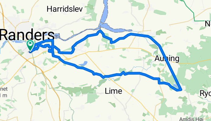
Rds. - Auning - Allingåbro - Rds.
A cycling route starting in Randers, Central Jutland, Denmark.
Overview
About this route
- -:--
- Duration
- 61.7 km
- Distance
- 337 m
- Ascent
- 340 m
- Descent
- ---
- Avg. speed
- 55 m
- Avg. speed

Route quality
Waytypes & surfaces along the route
Waytypes
Road
37.9 km
(61 %)
Quiet road
10.9 km
(18 %)
Surfaces
Paved
57.3 km
(93 %)
Unpaved
1.9 km
(3 %)
Asphalt
57.3 km
(93 %)
Gravel
1.9 km
(3 %)
Continue with Bikemap
Use, edit, or download this cycling route
You would like to ride Rds. - Auning - Allingåbro - Rds. or customize it for your own trip? Here is what you can do with this Bikemap route:
Free features
- Save this route as favorite or in collections
- Copy & plan your own version of this route
- Sync your route with Garmin or Wahoo
Premium features
Free trial for 3 days, or one-time payment. More about Bikemap Premium.
- Navigate this route on iOS & Android
- Export a GPX / KML file of this route
- Create your custom printout (try it for free)
- Download this route for offline navigation
Discover more Premium features.
Get Bikemap PremiumFrom our community
Other popular routes starting in Randers
 Fjordløbet Randers 100km
- Distance
- 100.7 km
- Ascent
- 343 m
- Descent
- 344 m
- Location
- Randers, Central Jutland, Denmark
 Randershpvsøndag
- Distance
- 55.3 km
- Ascent
- 180 m
- Descent
- 195 m
- Location
- Randers, Central Jutland, Denmark
 Operaen - Randers Dyrehave - Operaen
- Distance
- 12.3 km
- Ascent
- 23 m
- Descent
- 27 m
- Location
- Randers, Central Jutland, Denmark
 Fladbro/Fugletårn
- Distance
- 10.4 km
- Ascent
- 8 m
- Descent
- 9 m
- Location
- Randers, Central Jutland, Denmark
 randershpvlørdagkortrute
- Distance
- 46.2 km
- Ascent
- 269 m
- Descent
- 269 m
- Location
- Randers, Central Jutland, Denmark
 Randers S Langå Stevnstrup
- Distance
- 32.2 km
- Ascent
- 184 m
- Descent
- 184 m
- Location
- Randers, Central Jutland, Denmark
 Vester Velling
- Distance
- 33 km
- Ascent
- 210 m
- Descent
- 209 m
- Location
- Randers, Central Jutland, Denmark
 Rundt om Gudenåen
- Distance
- 31.6 km
- Ascent
- 235 m
- Descent
- 235 m
- Location
- Randers, Central Jutland, Denmark
Open it in the app