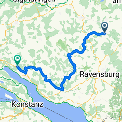
Allgäu - Oberschwaben Bäder-Rundtour
A cycling route starting in Aulendorf, Baden-Wurttemberg, Germany.
Overview
About this route
This circular tour takes you through the beautiful Oberschwaben and towns with thermal baths/pools. The beginning is based on the Swabian Spa Cycle Route, while from Bad Saulgau you cycle somewhat off the more frequented bike paths. Both scenic and cultural, it’s an appealing route that can be comfortably done as a day trip with some breaks. (Tour description at: thod_er@gmx.de)
- -:--
- Duration
- 56.3 km
- Distance
- 577 m
- Ascent
- 575 m
- Descent
- ---
- Avg. speed
- 677 m
- Max. altitude
Route quality
Waytypes & surfaces along the route
Waytypes
Quiet road
27.6 km
(49 %)
Road
10.7 km
(19 %)
Surfaces
Paved
39.4 km
(70 %)
Unpaved
2.8 km
(5 %)
Asphalt
37.2 km
(66 %)
Loose gravel
2.8 km
(5 %)
Continue with Bikemap
Use, edit, or download this cycling route
You would like to ride Allgäu - Oberschwaben Bäder-Rundtour or customize it for your own trip? Here is what you can do with this Bikemap route:
Free features
- Save this route as favorite or in collections
- Copy & plan your own version of this route
- Sync your route with Garmin or Wahoo
Premium features
Free trial for 3 days, or one-time payment. More about Bikemap Premium.
- Navigate this route on iOS & Android
- Export a GPX / KML file of this route
- Create your custom printout (try it for free)
- Download this route for offline navigation
Discover more Premium features.
Get Bikemap PremiumFrom our community
Other popular routes starting in Aulendorf
- Elchenreute Baienfurt Elchenreute
- Distance
- 19.6 km
- Ascent
- 89 m
- Descent
- 191 m
- Location
- Aulendorf, Baden-Wurttemberg, Germany
- Woche 1 Steege
- Distance
- 5.5 km
- Ascent
- 46 m
- Descent
- 49 m
- Location
- Aulendorf, Baden-Wurttemberg, Germany
- Von der Schussen an die Riß
- Distance
- 38.2 km
- Ascent
- 121 m
- Descent
- 121 m
- Location
- Aulendorf, Baden-Wurttemberg, Germany
- Aulendorf - Bodensee - Rheinfall - Tübingen
- Distance
- 268.6 km
- Ascent
- 2,958 m
- Descent
- 3,155 m
- Location
- Aulendorf, Baden-Wurttemberg, Germany
- Aulendorfer Runde
- Distance
- 53.8 km
- Ascent
- 526 m
- Descent
- 486 m
- Location
- Aulendorf, Baden-Wurttemberg, Germany
- leider mit Steigung :-)
- Distance
- 2.4 km
- Ascent
- 118 m
- Descent
- 101 m
- Location
- Aulendorf, Baden-Wurttemberg, Germany
- Woche 3 - Elchenreuterweiher
- Distance
- 10.6 km
- Ascent
- 34 m
- Descent
- 33 m
- Location
- Aulendorf, Baden-Wurttemberg, Germany
- Aulendorf-Wangen-Lindau-Friedrichshafen
- Distance
- 94.3 km
- Ascent
- 872 m
- Descent
- 1,018 m
- Location
- Aulendorf, Baden-Wurttemberg, Germany
Open it in the app