

Hochwasser - Teldau MiniTour
A cycling route starting in Boizenburg, Mecklenburg-Vorpommern, Germany.
Overview
About this route
- 1 h 51 min
- Duration
- 17.8 km
- Distance
- 10 m
- Ascent
- 3 m
- Descent
- 9.6 km/h
- Avg. speed
- 13 m
- Max. altitude

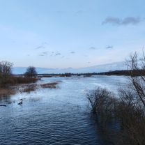
Route photos


Route quality
Waytypes & surfaces along the route
Waytypes
Path
6.9 km
(39 %)
Quiet road
3.9 km
(22 %)
Surfaces
Paved
11.5 km
(65 %)
Unpaved
1.8 km
(10 %)
Asphalt
11.5 km
(65 %)
Ground
1.8 km
(10 %)
Undefined
4.4 km
(25 %)
Continue with Bikemap
Use, edit, or download this cycling route
You would like to ride Hochwasser - Teldau MiniTour or customize it for your own trip? Here is what you can do with this Bikemap route:
Free features
- Save this route as favorite or in collections
- Copy & plan your own version of this route
- Sync your route with Garmin or Wahoo
Premium features
Free trial for 3 days, or one-time payment. More about Bikemap Premium.
- Navigate this route on iOS & Android
- Export a GPX / KML file of this route
- Create your custom printout (try it for free)
- Download this route for offline navigation
Discover more Premium features.
Get Bikemap PremiumFrom our community
Other popular routes starting in Boizenburg
 Bengerstorf: Natur mit Kultur
- Distance
- 56.4 km
- Ascent
- 157 m
- Descent
- 157 m
- Location
- Boizenburg, Mecklenburg-Vorpommern, Germany
 Off-road Race Mix tour
- Distance
- 3.4 km
- Ascent
- 56 m
- Descent
- 80 m
- Location
- Boizenburg, Mecklenburg-Vorpommern, Germany
 Hochwasser - Teldau MiniTour
- Distance
- 17.8 km
- Ascent
- 10 m
- Descent
- 3 m
- Location
- Boizenburg, Mecklenburg-Vorpommern, Germany
 Toitewinkel - Schwanheide - Train Tour
- Distance
- 19.8 km
- Ascent
- 59 m
- Descent
- 112 m
- Location
- Boizenburg, Mecklenburg-Vorpommern, Germany
 Teldauer Grünland Tour (Boizenburg - Teldau - Neu Bleckede - Boizenburg)
- Distance
- 34.5 km
- Ascent
- 59 m
- Descent
- 102 m
- Location
- Boizenburg, Mecklenburg-Vorpommern, Germany
 Boizenburg östlich
- Distance
- 43.7 km
- Ascent
- 22 m
- Descent
- 19 m
- Location
- Boizenburg, Mecklenburg-Vorpommern, Germany
 Schwartow - Hatzbergtour
- Distance
- 18.1 km
- Ascent
- 77 m
- Descent
- 120 m
- Location
- Boizenburg, Mecklenburg-Vorpommern, Germany
 Grünes Band_Tag 3_Boizenburg - Dömitz
- Distance
- 66.1 km
- Ascent
- 194 m
- Descent
- 185 m
- Location
- Boizenburg, Mecklenburg-Vorpommern, Germany
Open it in the app