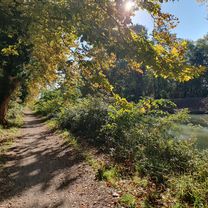
castlenaudary - carcassonne
A cycling route starting in Castelnaudary, Occitanie, France.
Overview
About this route
- -:--
- Duration
- 38.1 km
- Distance
- 46 m
- Ascent
- 86 m
- Descent
- ---
- Avg. speed
- 163 m
- Max. altitude
Route quality
Waytypes & surfaces along the route
Waytypes
Track
23.6 km
(62 %)
Path
9.5 km
(25 %)
Surfaces
Paved
3.8 km
(10 %)
Unpaved
33.2 km
(87 %)
Gravel
14.9 km
(39 %)
Loose gravel
11.1 km
(29 %)
Route highlights
Points of interest along the route
Accommodation after 0 km
ibis
Accommodation after 0 km
camping municipal val de garonne
Accommodation after 0 km
camping du moulin de bidounet
Continue with Bikemap
Use, edit, or download this cycling route
You would like to ride castlenaudary - carcassonne or customize it for your own trip? Here is what you can do with this Bikemap route:
Free features
- Save this route as favorite or in collections
- Copy & plan your own version of this route
- Sync your route with Garmin or Wahoo
Premium features
Free trial for 3 days, or one-time payment. More about Bikemap Premium.
- Navigate this route on iOS & Android
- Export a GPX / KML file of this route
- Create your custom printout (try it for free)
- Download this route for offline navigation
Discover more Premium features.
Get Bikemap PremiumFrom our community
Other popular routes starting in Castelnaudary
Chemin des Fontanilles, Castelnaudary to Carcassonne- Distance
- 42.8 km
- Ascent
- 134 m
- Descent
- 203 m
- Location
- Castelnaudary, Occitanie, France
11.10.25 Castelnaudary Bram Carcassonne- Distance
- 51.5 km
- Ascent
- 103 m
- Descent
- 203 m
- Location
- Castelnaudary, Occitanie, France
Test- Distance
- 12.7 km
- Ascent
- 16 m
- Descent
- 55 m
- Location
- Castelnaudary, Occitanie, France
Castelnaudary / Bram- Distance
- 16.7 km
- Ascent
- 3 m
- Descent
- 50 m
- Location
- Castelnaudary, Occitanie, France
castlenaudary - carcassonne- Distance
- 38.1 km
- Ascent
- 46 m
- Descent
- 86 m
- Location
- Castelnaudary, Occitanie, France
From Castelnaudary to Béziers- Distance
- 222.8 km
- Ascent
- 2,457 m
- Descent
- 2,615 m
- Location
- Castelnaudary, Occitanie, France
canal j5- Distance
- 68.6 km
- Ascent
- 59 m
- Descent
- 116 m
- Location
- Castelnaudary, Occitanie, France
20250807 CASTELNAUDARY-CARCASONNE- Distance
- 45.5 km
- Ascent
- 153 m
- Descent
- 228 m
- Location
- Castelnaudary, Occitanie, France
Open it in the app

