

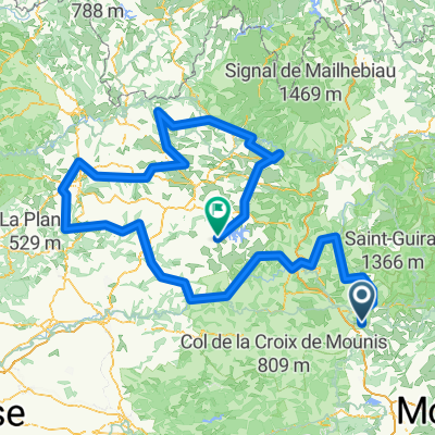
TMC7_St Jean du Bruel - Ceilhes Roqueredonde
A cycling route starting in La Cavalerie, Occitanie, France.
Overview
About this route
null
- 3 h 31 min
- Duration
- 49 km
- Distance
- 1,076 m
- Ascent
- 1,150 m
- Descent
- 14 km/h
- Avg. speed
- 871 m
- Max. altitude

Route quality
Waytypes & surfaces along the route
Waytypes
Road
27 km
(55 %)
Track
15.7 km
(32 %)
Surfaces
Paved
2.9 km
(6 %)
Unpaved
3.9 km
(8 %)
Paved (undefined)
2.5 km
(5 %)
Gravel
2.5 km
(5 %)
Continue with Bikemap
Use, edit, or download this cycling route
You would like to ride TMC7_St Jean du Bruel - Ceilhes Roqueredonde or customize it for your own trip? Here is what you can do with this Bikemap route:
Free features
- Save this route as favorite or in collections
- Copy & plan your own version of this route
- Sync your route with Garmin or Wahoo
Premium features
Free trial for 3 days, or one-time payment. More about Bikemap Premium.
- Navigate this route on iOS & Android
- Export a GPX / KML file of this route
- Create your custom printout (try it for free)
- Download this route for offline navigation
Discover more Premium features.
Get Bikemap PremiumFrom our community
Other popular routes starting in La Cavalerie
 Okolo řeky La Trévezel
- Distance
- 57.4 km
- Ascent
- 868 m
- Descent
- 878 m
- Location
- La Cavalerie, Occitanie, France
 Larzac Ascencion 2010- Jour 4
- Distance
- 49.1 km
- Ascent
- 774 m
- Descent
- 1,259 m
- Location
- La Cavalerie, Occitanie, France
 tour de l Aveyron en vélo
- Distance
- 491.6 km
- Ascent
- 15,735 m
- Descent
- 15,796 m
- Location
- La Cavalerie, Occitanie, France
 Cevennen-Tour 2007 Tag 3
- Distance
- 69 km
- Ascent
- 1,691 m
- Descent
- 1,802 m
- Location
- La Cavalerie, Occitanie, France
 millau larzac viala de pas de jaux
- Distance
- 75.3 km
- Ascent
- 920 m
- Descent
- 1,183 m
- Location
- La Cavalerie, Occitanie, France
 Route 1 - rondje 33 km - 570 hm
- Distance
- 32.5 km
- Ascent
- 708 m
- Descent
- 724 m
- Location
- La Cavalerie, Occitanie, France
 La Couvertoirade / Lunas
- Distance
- 54.8 km
- Ascent
- 1,265 m
- Descent
- 1,760 m
- Location
- La Cavalerie, Occitanie, France
 Larzac Ascencion 2010- Jour 2
- Distance
- 55.3 km
- Ascent
- 642 m
- Descent
- 641 m
- Location
- La Cavalerie, Occitanie, France
Open it in the app