

Overview
About this route
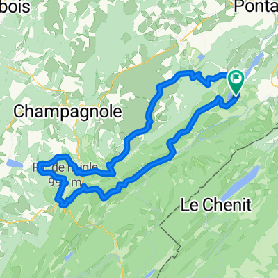
- 10 h 1 min
- Duration
- 145.9 km
- Distance
- 2,388 m
- Ascent
- 2,387 m
- Descent
- 14.6 km/h
- Avg. speed
- 966 m
- Max. altitude
Part of
Jura
6 stages
Route quality
Waytypes & surfaces along the route
Waytypes
Road
42.3 km
(29 %)
Quiet road
16 km
(11 %)
Surfaces
Paved
87.5 km
(60 %)
Unpaved
1.5 km
(1 %)
Asphalt
87.5 km
(60 %)
Gravel
1.5 km
(1 %)
Undefined
56.9 km
(39 %)
Continue with Bikemap
Use, edit, or download this cycling route
You would like to ride Tour 1 or customize it for your own trip? Here is what you can do with this Bikemap route:
Free features
- Save this route as favorite or in collections
- Copy & plan your own version of this route
- Split it into stages to create a multi-day tour
- Sync your route with Garmin or Wahoo
Premium features
Free trial for 3 days, or one-time payment. More about Bikemap Premium.
- Navigate this route on iOS & Android
- Export a GPX / KML file of this route
- Create your custom printout (try it for free)
- Download this route for offline navigation
Discover more Premium features.
Get Bikemap PremiumFrom our community
Other popular routes starting in Jougne
 Remoray Lac
- Distance
- 117.8 km
- Ascent
- 1,943 m
- Descent
- 1,941 m
- Location
- Jougne, Bourgogne-Franche-Comté, France
 Hôpitaux Neufs Mots du Jura F/CH
- Distance
- 85.3 km
- Ascent
- 1,636 m
- Descent
- 1,634 m
- Location
- Jougne, Bourgogne-Franche-Comté, France
 Grande Traversée du Jura - Etape 3 : Métabief / Les Rousses (65 km / D+ 1300 m)
- Distance
- 64.9 km
- Ascent
- 1,028 m
- Descent
- 887 m
- Location
- Jougne, Bourgogne-Franche-Comté, France
 domingo
- Distance
- 73.4 km
- Ascent
- 545 m
- Descent
- 506 m
- Location
- Jougne, Bourgogne-Franche-Comté, France
 Lac de Remoray-Mouthe
- Distance
- 48.4 km
- Ascent
- 723 m
- Descent
- 649 m
- Location
- Jougne, Bourgogne-Franche-Comté, France
 Domingo de Manhattan
- Distance
- 62.1 km
- Ascent
- 258 m
- Descent
- 833 m
- Location
- Jougne, Bourgogne-Franche-Comté, France
 lac st-point tour
- Distance
- 20.1 km
- Ascent
- 177 m
- Descent
- 163 m
- Location
- Jougne, Bourgogne-Franche-Comté, France
 Lac de Remory-Mouthe
- Distance
- 46.7 km
- Ascent
- 655 m
- Descent
- 602 m
- Location
- Jougne, Bourgogne-Franche-Comté, France
Open it in the app