

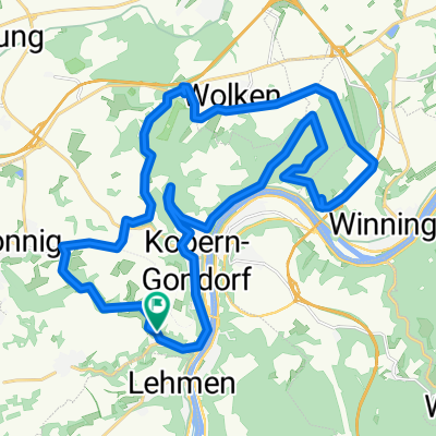
Niederfell, Bachstr., Grillh., Bleidenb., Kelt. Mauer, Röder-Kap., AT Mönch-Felix-Hütte 24km 520Hm
A cycling route starting in Kobern-Gondorf, Rhineland-Palatinate, Germany.
Overview
About this route
Start auf dem Mitfahrerparkplatz Kobern-Gondorf unter der Moselbrücke, über Brücke nach Niederfell, Bachstr K70, Abstecher Grillhütte, Bachstr.K70, aus Aspeler Bachtal im Niederfeller Wald rechts abbiegen, nun auf K71, links ab zum Bleidenberg, Dreifaltigkeitskapelle, Bleidenberger Hof, Allee Bleidenberg mit Aussichtsplateau Oberfell, Keltischer Mauer, Skulpturenpark und Abstecher Freiheitstempel, Zurück auf K71, bei Kurfürsten-Ruh rechts ab Waldstrecke mit Anstieg Auf der Schild, Röder-Kapelle, Allee,Feller Hof, Feuerrosenweg, Ausblick Johanniskirche, Kuckuckshöhe mit Aussichtsturm Mönch-Felix-Hütte, Nachtigallenweg, Bachstr., Niederfell, Einkehr im Gasthaus Traube, über Brücke zum Parkplatz, ca.24km, 520 Hm
- -:--
- Duration
- 22.6 km
- Distance
- 662 m
- Ascent
- 664 m
- Descent
- ---
- Avg. speed
- 369 m
- Max. altitude
Route quality
Waytypes & surfaces along the route
Waytypes
Track
11.4 km
(51 %)
Quiet road
3.5 km
(16 %)
Surfaces
Paved
15.1 km
(67 %)
Unpaved
6.7 km
(30 %)
Asphalt
13.8 km
(61 %)
Gravel
5.1 km
(22 %)
Continue with Bikemap
Use, edit, or download this cycling route
You would like to ride Niederfell, Bachstr., Grillh., Bleidenb., Kelt. Mauer, Röder-Kap., AT Mönch-Felix-Hütte 24km 520Hm or customize it for your own trip? Here is what you can do with this Bikemap route:
Free features
- Save this route as favorite or in collections
- Copy & plan your own version of this route
- Sync your route with Garmin or Wahoo
Premium features
Free trial for 3 days, or one-time payment. More about Bikemap Premium.
- Navigate this route on iOS & Android
- Export a GPX / KML file of this route
- Create your custom printout (try it for free)
- Download this route for offline navigation
Discover more Premium features.
Get Bikemap PremiumFrom our community
Other popular routes starting in Kobern-Gondorf
 Koblenz 15km Moselaufwärts
- Distance
- 37.4 km
- Ascent
- 111 m
- Descent
- 119 m
- Location
- Kobern-Gondorf, Rhineland-Palatinate, Germany
 schöne tour nachgefahren 2
- Distance
- 30.7 km
- Ascent
- 536 m
- Descent
- 536 m
- Location
- Kobern-Gondorf, Rhineland-Palatinate, Germany
 730km teil 2
- Distance
- 728.5 km
- Ascent
- 6,746 m
- Descent
- 6,751 m
- Location
- Kobern-Gondorf, Rhineland-Palatinate, Germany
 Niederfell, Bachstr., Grillh., Bleidenb., Kelt. Mauer, Röder-Kap., AT Mönch-Felix-Hütte 24km 520Hm
- Distance
- 22.6 km
- Ascent
- 662 m
- Descent
- 664 m
- Location
- Kobern-Gondorf, Rhineland-Palatinate, Germany
 Kobern Gondorf - Trabentrarbach
- Distance
- 70 km
- Ascent
- 581 m
- Descent
- 566 m
- Location
- Kobern-Gondorf, Rhineland-Palatinate, Germany
 mtb kobern lonnig wolken gondorf
- Distance
- 29.8 km
- Ascent
- 590 m
- Descent
- 590 m
- Location
- Kobern-Gondorf, Rhineland-Palatinate, Germany
 Kehrhof, Kobern-Gondorf nach Kehrhof, Kobern-Gondorf
- Distance
- 43.4 km
- Ascent
- 398 m
- Descent
- 406 m
- Location
- Kobern-Gondorf, Rhineland-Palatinate, Germany
 mosel
mosel- Distance
- 195.6 km
- Ascent
- 286 m
- Descent
- 224 m
- Location
- Kobern-Gondorf, Rhineland-Palatinate, Germany
Open it in the app