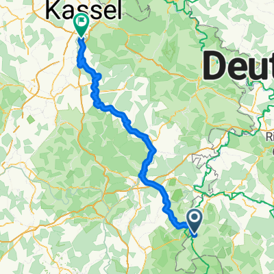
Geisa nach Hof
A cycling route starting in Geisa, Free State of Thuringia, Germany.
Overview
About this route
- -:--
- Duration
- 316.7 km
- Distance
- 4,675 m
- Ascent
- 4,485 m
- Descent
- ---
- Avg. speed
- 798 m
- Avg. speed
Route quality
Waytypes & surfaces along the route
Waytypes
Busy road
82.5 km
(26 %)
Road
79.8 km
(25 %)
Surfaces
Paved
163 km
(51 %)
Unpaved
25.4 km
(8 %)
Asphalt
153.4 km
(48 %)
Gravel
14.8 km
(5 %)
Continue with Bikemap
Use, edit, or download this cycling route
You would like to ride Geisa nach Hof or customize it for your own trip? Here is what you can do with this Bikemap route:
Free features
- Save this route as favorite or in collections
- Copy & plan your own version of this route
- Sync your route with Garmin or Wahoo
Premium features
Free trial for 3 days, or one-time payment. More about Bikemap Premium.
- Navigate this route on iOS & Android
- Export a GPX / KML file of this route
- Create your custom printout (try it for free)
- Download this route for offline navigation
Discover more Premium features.
Get Bikemap PremiumFrom our community
Other popular routes starting in Geisa
- Geisa nach Fulda
- Distance
- 58.1 km
- Ascent
- 572 m
- Descent
- 570 m
- Location
- Geisa, Free State of Thuringia, Germany
- Rhöntour
- Distance
- 47.7 km
- Ascent
- 877 m
- Descent
- 877 m
- Location
- Geisa, Free State of Thuringia, Germany
- Tagestour Ulstertal - Tagestour Ulstertal
- Distance
- 42.6 km
- Ascent
- 441 m
- Descent
- 420 m
- Location
- Geisa, Free State of Thuringia, Germany
- Von Geisa bis Hofbieber
- Distance
- 32.9 km
- Ascent
- 686 m
- Descent
- 186 m
- Location
- Geisa, Free State of Thuringia, Germany
- Geisa - Bad Hersfeld
- Distance
- 77.5 km
- Ascent
- 358 m
- Descent
- 450 m
- Location
- Geisa, Free State of Thuringia, Germany
- Geisa - Eisenach
- Distance
- 70.8 km
- Ascent
- 234 m
- Descent
- 300 m
- Location
- Geisa, Free State of Thuringia, Germany
- BR-Kanz-Lämm-BR
- Distance
- 23.9 km
- Ascent
- 563 m
- Descent
- 565 m
- Location
- Geisa, Free State of Thuringia, Germany
- Geisa - Hünfeld 28
- Distance
- 22.8 km
- Ascent
- 425 m
- Descent
- 422 m
- Location
- Geisa, Free State of Thuringia, Germany
Open it in the app