
Belenilvat - Murtiçi
A cycling route starting in Akseki, Antalya Province, Republic of Türkiye.
Overview
About this route
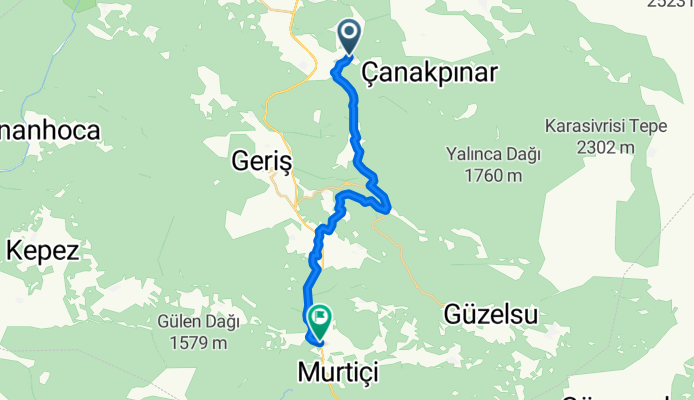
Isauria Yolu 3: Belenilvat - Murtiçinear Belenalan, Antalya (Turkey) by Konya Doğa Rotaları Walking distance: 21 km. Elevation min: 502 meters max: 1055 meters Uphill: 521 meters down: 1048 meters Type: One way Our route continues towards Gündoğmuş... The 3rd stage, starting from Belenilvat and continuing to Murtiçi, has a total walking distance of 30.5 km... »read more → Upload your trail to wikiloc.com →
- -:--
- Duration
- 21 km
- Distance
- 643 m
- Ascent
- 1,174 m
- Descent
- ---
- Avg. speed
- 1,056 m
- Max. altitude

Continue with Bikemap
Use, edit, or download this cycling route
You would like to ride Belenilvat - Murtiçi or customize it for your own trip? Here is what you can do with this Bikemap route:
Free features
- Save this route as favorite or in collections
- Copy & plan your own version of this route
- Sync your route with Garmin or Wahoo
Premium features
Free trial for 3 days, or one-time payment. More about Bikemap Premium.
- Navigate this route on iOS & Android
- Export a GPX / KML file of this route
- Create your custom printout (try it for free)
- Download this route for offline navigation
Discover more Premium features.
Get Bikemap PremiumFrom our community
Other popular routes starting in Akseki
 Akseki -Manavgat
- Distance
- 79.6 km
- Ascent
- 411 m
- Descent
- 1,636 m
- Location
- Akseki, Antalya Province, Republic of Türkiye
 Akseki - Seydisehir
- Distance
- 72.5 km
- Ascent
- 1,300 m
- Descent
- 1,249 m
- Location
- Akseki, Antalya Province, Republic of Türkiye
 Belenilvat - Murtiçi
- Distance
- 21 km
- Ascent
- 643 m
- Descent
- 1,174 m
- Location
- Akseki, Antalya Province, Republic of Türkiye
 turkey 06
- Distance
- 228.6 km
- Ascent
- 2,853 m
- Descent
- 2,899 m
- Location
- Akseki, Antalya Province, Republic of Türkiye
Open it in the app