

Murtiçi - Çaltılıçukur
A cycling route starting in Güzelsu, Antalya Province, Republic of Türkiye.
Overview
About this route
Isauria Route 4: Murtiçi - Çaltılıçukurnear Taşlıca, Antalya (Turkey) by Konya Doğa Rotaları Walking distance: 27 km. Elevation min: 426 meters max: 1049 meters Uphill: 1452 meters downhill: 1087 meters Type: One way The 4th stage starts at Murtiçi and continues to Çaltılıçukur, with a total walking distance of 33 km. 4TH STAGE DISTANCES Murtiçi – Fersin –... ">read more →Upload your trail to wikiloc.com → -
- -:--
- Duration
- 27.3 km
- Distance
- 1,609 m
- Ascent
- 1,245 m
- Descent
- ---
- Avg. speed
- 1,050 m
- Max. altitude

Continue with Bikemap
Use, edit, or download this cycling route
You would like to ride Murtiçi - Çaltılıçukur or customize it for your own trip? Here is what you can do with this Bikemap route:
Free features
- Save this route as favorite or in collections
- Copy & plan your own version of this route
- Sync your route with Garmin or Wahoo
Premium features
Free trial for 3 days, or one-time payment. More about Bikemap Premium.
- Navigate this route on iOS & Android
- Export a GPX / KML file of this route
- Create your custom printout (try it for free)
- Download this route for offline navigation
Discover more Premium features.
Get Bikemap PremiumFrom our community
Other popular routes starting in Güzelsu
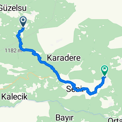 Çaltılıçukur - Gündoğmuş
- Distance
- 23.3 km
- Ascent
- 1,254 m
- Descent
- 1,219 m
- Location
- Güzelsu, Antalya Province, Republic of Türkiye
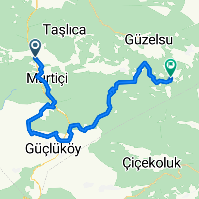 Murtiçi - Çaltılıçukur
- Distance
- 27.3 km
- Ascent
- 1,609 m
- Descent
- 1,245 m
- Location
- Güzelsu, Antalya Province, Republic of Türkiye
 TURKEY MOUNTAIN LAKE
- Distance
- 80.6 km
- Ascent
- 1,549 m
- Descent
- 620 m
- Location
- Güzelsu, Antalya Province, Republic of Türkiye
Open it in the app