

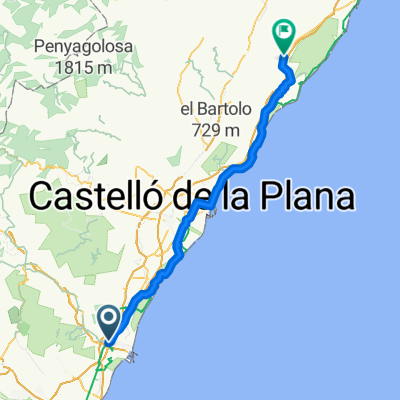
Dag 2: Sagunto - Castello de la plana - 54 km
A cycling route starting in Sagunto, Valencia, Spain.
Overview
About this route
- -:--
- Duration
- 53.7 km
- Distance
- 1,612 m
- Ascent
- 1,512 m
- Descent
- ---
- Avg. speed
- 1,172 m
- Max. altitude

Route quality
Waytypes & surfaces along the route
Waytypes
Quiet road
40.3 km
(75 %)
Cycleway
4.3 km
(8 %)
Surfaces
Paved
35.5 km
(66 %)
Unpaved
2.1 km
(4 %)
Asphalt
33.8 km
(63 %)
Paved (undefined)
1.1 km
(2 %)
Continue with Bikemap
Use, edit, or download this cycling route
You would like to ride Dag 2: Sagunto - Castello de la plana - 54 km or customize it for your own trip? Here is what you can do with this Bikemap route:
Free features
- Save this route as favorite or in collections
- Copy & plan your own version of this route
- Sync your route with Garmin or Wahoo
Premium features
Free trial for 3 days, or one-time payment. More about Bikemap Premium.
- Navigate this route on iOS & Android
- Export a GPX / KML file of this route
- Create your custom printout (try it for free)
- Download this route for offline navigation
Discover more Premium features.
Get Bikemap PremiumFrom our community
Other popular routes starting in Sagunto
 Sagunto - Antenas Picayo - Pico Aguila - Mola - Xocainet - Gilet -Sagunto
- Distance
- 34.7 km
- Ascent
- 709 m
- Descent
- 709 m
- Location
- Sagunto, Valencia, Spain
 puerto sagunto-aqüeducte dels arcs-torres torres-puerto sagunto-
- Distance
- 38.2 km
- Ascent
- 313 m
- Descent
- 310 m
- Location
- Sagunto, Valencia, Spain
 Sagunt, Petrés, bosque ,sendas, fuente, barranco y Castillo
- Distance
- 21.8 km
- Ascent
- 445 m
- Descent
- 446 m
- Location
- Sagunto, Valencia, Spain
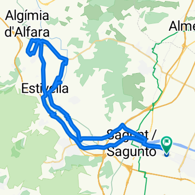
 Sagunto circular por Alfara y Torres Torres
- Distance
- 40.3 km
- Ascent
- 403 m
- Descent
- 402 m
- Location
- Sagunto, Valencia, Spain
 SAGUNTO PICAYO LA MOLA
- Distance
- 29.1 km
- Ascent
- 566 m
- Descent
- 567 m
- Location
- Sagunto, Valencia, Spain
 Sagunto - Alcalà de Xivert
- Distance
- 99.6 km
- Ascent
- 379 m
- Descent
- 269 m
- Location
- Sagunto, Valencia, Spain
 ALFORJAS POR CASTELLÓN
- Distance
- 344.1 km
- Ascent
- 3,486 m
- Descent
- 3,522 m
- Location
- Sagunto, Valencia, Spain
 Dag 2: Sagunto - Castello de la plana - 54 km
- Distance
- 53.7 km
- Ascent
- 1,612 m
- Descent
- 1,512 m
- Location
- Sagunto, Valencia, Spain
Open it in the app