

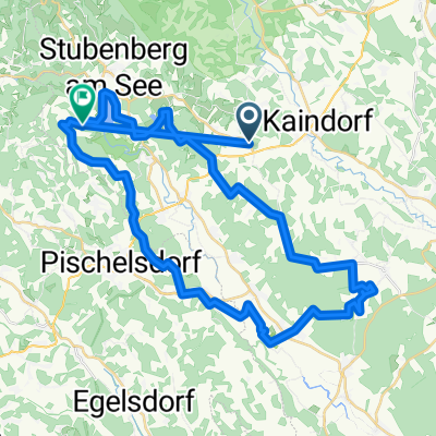
Runde Pöllauer Tal
A cycling route starting in Dienersdorf, Styria, Austria.
Overview
About this route
- -:--
- Duration
- 46.2 km
- Distance
- 1,588 m
- Ascent
- 1,588 m
- Descent
- ---
- Avg. speed
- ---
- Max. altitude

Continue with Bikemap
Use, edit, or download this cycling route
You would like to ride Runde Pöllauer Tal or customize it for your own trip? Here is what you can do with this Bikemap route:
Free features
- Save this route as favorite or in collections
- Copy & plan your own version of this route
- Sync your route with Garmin or Wahoo
Premium features
Free trial for 3 days, or one-time payment. More about Bikemap Premium.
- Navigate this route on iOS & Android
- Export a GPX / KML file of this route
- Create your custom printout (try it for free)
- Download this route for offline navigation
Discover more Premium features.
Get Bikemap PremiumFrom our community
Other popular routes starting in Dienersdorf
 radrunde
- Distance
- 52.3 km
- Ascent
- 684 m
- Descent
- 605 m
- Location
- Dienersdorf, Styria, Austria
 Hofkirchen bei Hartberg nach Hofkirchen bei Hartberg
- Distance
- 5.1 km
- Ascent
- 3 m
- Descent
- 0 m
- Location
- Dienersdorf, Styria, Austria
 Sankt Stefan Runde 2019
- Distance
- 80.6 km
- Ascent
- 730 m
- Descent
- 730 m
- Location
- Dienersdorf, Styria, Austria
 Schöneggtour HB9 - Anspruchsvolle Radtour
- Distance
- 7.8 km
- Ascent
- 354 m
- Descent
- 281 m
- Location
- Dienersdorf, Styria, Austria
 Winzendorf, Pöllau nach Buchberg 25, Stubenberg
- Distance
- 14.5 km
- Ascent
- 662 m
- Descent
- 616 m
- Location
- Dienersdorf, Styria, Austria
 Radtour St. Gotthart
- Distance
- 53.2 km
- Ascent
- 109 m
- Descent
- 295 m
- Location
- Dienersdorf, Styria, Austria
 Winzendorf rund um Rabenwaldkogel und Buchkogel
- Distance
- 66.6 km
- Ascent
- 742 m
- Descent
- 743 m
- Location
- Dienersdorf, Styria, Austria
 Hofkirchen nach Hofkirchen
- Distance
- 36.1 km
- Ascent
- 893 m
- Descent
- 893 m
- Location
- Dienersdorf, Styria, Austria
Open it in the app