

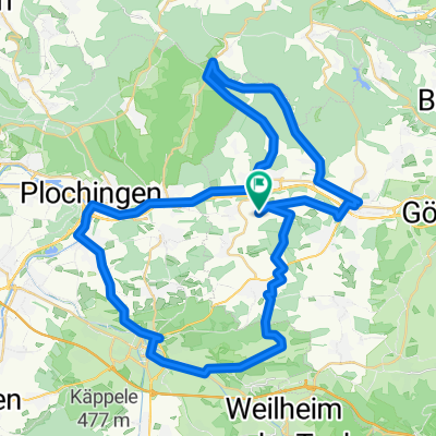
Sulpach-Täle-Neidlingen-Sulpach
A cycling route starting in Ebersbach an der Fils, Baden-Wurttemberg, Germany.
Overview
About this route
Gradient ratio 15.1 Hm/km Reference: Alb Extrem 190 km = 14.7 Hm/km
- -:--
- Duration
- 62.1 km
- Distance
- 1,098 m
- Ascent
- 1,078 m
- Descent
- ---
- Avg. speed
- 743 m
- Max. altitude

Route quality
Waytypes & surfaces along the route
Waytypes
Road
24.2 km
(39 %)
Track
9.3 km
(15 %)
Surfaces
Paved
41.6 km
(67 %)
Unpaved
0.6 km
(1 %)
Asphalt
37.3 km
(60 %)
Paved (undefined)
3.7 km
(6 %)
Continue with Bikemap
Use, edit, or download this cycling route
You would like to ride Sulpach-Täle-Neidlingen-Sulpach or customize it for your own trip? Here is what you can do with this Bikemap route:
Free features
- Save this route as favorite or in collections
- Copy & plan your own version of this route
- Sync your route with Garmin or Wahoo
Premium features
Free trial for 3 days, or one-time payment. More about Bikemap Premium.
- Navigate this route on iOS & Android
- Export a GPX / KML file of this route
- Create your custom printout (try it for free)
- Download this route for offline navigation
Discover more Premium features.
Get Bikemap PremiumFrom our community
Other popular routes starting in Ebersbach an der Fils
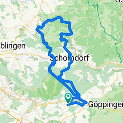
 Sulpach-Hornberg-Weilerstoffel-Aasrücken-Sulpach
- Distance
- 80.2 km
- Ascent
- 1,186 m
- Descent
- 1,203 m
- Location
- Ebersbach an der Fils, Baden-Wurttemberg, Germany
 Von Ebersbach an den Herrenbachstausee
- Distance
- 25.3 km
- Ascent
- 570 m
- Descent
- 479 m
- Location
- Ebersbach an der Fils, Baden-Wurttemberg, Germany
 Sulpach-Kirchheim-Wernau-Eberbach-Krapfenreut-Nassachtal-Uhingen-Bünzwangen-Sulpach
- Distance
- 58.4 km
- Ascent
- 525 m
- Descent
- 524 m
- Location
- Ebersbach an der Fils, Baden-Wurttemberg, Germany
 Über die Eisenbahntasse nach Schw. Gmünd und über die Kaiserberge zurück
- Distance
- 69.2 km
- Ascent
- 932 m
- Descent
- 947 m
- Location
- Ebersbach an der Fils, Baden-Wurttemberg, Germany
 K 1419, Ebersbach an der Fils nach Im Morgen, Albershausen
- Distance
- 30.4 km
- Ascent
- 398 m
- Descent
- 396 m
- Location
- Ebersbach an der Fils, Baden-Wurttemberg, Germany
 Rundfahrt kleines Lautertal, Kirchheim
- Distance
- 43.5 km
- Ascent
- 173 m
- Descent
- 173 m
- Location
- Ebersbach an der Fils, Baden-Wurttemberg, Germany
 Sulpach-Täle-Neidlingen-Sulpach
- Distance
- 62.1 km
- Ascent
- 1,098 m
- Descent
- 1,078 m
- Location
- Ebersbach an der Fils, Baden-Wurttemberg, Germany
 Sulpach-Spechtshof-Bürg-Schorndrf-Uhi.-Slpch
- Distance
- 84.6 km
- Ascent
- 1,394 m
- Descent
- 1,405 m
- Location
- Ebersbach an der Fils, Baden-Wurttemberg, Germany
Open it in the app