Sfittanze della Sega - Ala
- 78.8 km
- 1,357 m
- 1,358 m
- Ala, Trentino-Alto Adige, Italy
A cycling route starting in Ala, Trentino-Alto Adige, Italy.
Overview
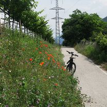
Nach etlichen tsd Höhenmeter die letzten Tage wollte ich es am 30.5 etwas gemächlicher angehen. Die ganze Tour läßt sich auch mit einen herkömmlichen Rad machen, ein E Antrieb ist aber immer von Vorteil, es kamen da dann doch fast 90 Km und über 500 Hm zusammen. Insbesondere der Berg zum Forte Wohlgemut ist nicht zu verachten, die Abfahrt ist mit Vorsicht zu genießen. Immer spektakulär die Panoramen, die sich allenthalben eröffnen, die Fahrt entlang des Kanals, sicherheitshalber eingezäunt, die vielen Wildblumen die scheinbar an jeder Ritze wachsen. Leider sind mir die Handyfotos verloren gegangen, sehr ärgerlich. In Ponton am Umkehrpunkt, entschließe ich mich noch spontan den Parco fluvale an der Etsch entlang zu radeln, etwas Trail für diesen Tag. Das war ne gute Idee, denn der Pfad ist Klasse. Ne ausgewachse Schlage kringelt sich in den Weg, ich kann grade noch anhalten ohne drüber zu fahren. Nach einem Rückzieher macht sie dann den Weg frei. Sehr urige Strecke. Ein Highlight der Steinbruch und anschließend die Etsch Klamm, die man nun endlich durchradeln kann. toll gemacht und danke schön. Im Weiteren ist es dann weniger spektakulär aber nett zu treten. Ich hatte die schnellen Reifen draufmontiert, mit den Maxxis wär's zu anstrengend gewesen und auch unnötig.
created this 1 year ago
\"")
\"")
\"")
\"")
\"")
\"")
\"")
\"")
Route quality
Cycleway
33.9 km
(38 %)
Path
19.6 km
(22 %)
Paved
69.6 km
(78 %)
Unpaved
10.7 km
(12 %)
Asphalt
69.6 km
(78 %)
Gravel
8 km
(9 %)
Continue with Bikemap
You would like to ride Ala Etsch Runde (88,3 km) or customize it for your own trip? Here is what you can do with this Bikemap route:
Free trial for 3 days, or one-time payment. More about Bikemap Premium.
Discover more Premium features.
Get Bikemap PremiumFrom our community
Open it in the app