
Morredero/Portillinos/Llano de las Ovejas
A cycling route starting in Ponferrada, Castille and León, Spain.
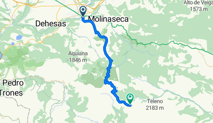
Overview
About this route
- -:--
- Duration
- 33.4 km
- Distance
- 1,595 m
- Ascent
- 165 m
- Descent
- ---
- Avg. speed
- 1,959 m
- Avg. speed

Route quality
Waytypes & surfaces along the route
Waytypes
Road
32.8 km
(98 %)
Busy road
0.4 km
(1 %)
Surfaces
Paved
13.2 km
(40 %)
Unpaved
0 km
(<1 %)
Asphalt
13.2 km
(39 %)
Ground
0 km
(<1 %)
Continue with Bikemap
Use, edit, or download this cycling route
You would like to ride Morredero/Portillinos/Llano de las Ovejas or customize it for your own trip? Here is what you can do with this Bikemap route:
Free features
- Save this route as favorite or in collections
- Copy & plan your own version of this route
- Sync your route with Garmin or Wahoo
Premium features
Free trial for 3 days, or one-time payment. More about Bikemap Premium.
- Navigate this route on iOS & Android
- Export a GPX / KML file of this route
- Create your custom printout (try it for free)
- Download this route for offline navigation
Discover more Premium features.
Get Bikemap PremiumFrom our community
Other popular routes starting in Ponferrada
 Ponferrada-Pena Trevinca-La Baña-Portillinos-Ponferrada
- Distance
- 150.9 km
- Ascent
- 2,727 m
- Descent
- 2,726 m
- Location
- Ponferrada, Castille and León, Spain
 Las Barrancas
- Distance
- 30.7 km
- Ascent
- 368 m
- Descent
- 368 m
- Location
- Ponferrada, Castille and León, Spain
 bordeando el rio sil
- Distance
- 16.6 km
- Ascent
- 459 m
- Descent
- 459 m
- Location
- Ponferrada, Castille and León, Spain
 Ponferrada Mondial 2014
- Distance
- 18.3 km
- Ascent
- 346 m
- Descent
- 347 m
- Location
- Ponferrada, Castille and León, Spain
 Ponferrada - O Cebreiro
- Distance
- 49.7 km
- Ascent
- 1,343 m
- Descent
- 553 m
- Location
- Ponferrada, Castille and León, Spain
 Circuito de Ponferrada (17,5 Km)
- Distance
- 17.5 km
- Ascent
- 383 m
- Descent
- 383 m
- Location
- Ponferrada, Castille and León, Spain
 Jakobsweg 37. Etappe Ponferrada - Sarria
- Distance
- 92.3 km
- Ascent
- 1,376 m
- Descent
- 1,492 m
- Location
- Ponferrada, Castille and León, Spain
 ruta circular pajariel las viñas
- Distance
- 29.3 km
- Ascent
- 556 m
- Descent
- 556 m
- Location
- Ponferrada, Castille and León, Spain
Open it in the app