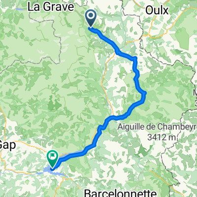
- 100.6 km
- 3,466 m
- 3,911 m
- Le Mon锚tier-les-Bains, Provence-Alpes-C么te d'Azur Region, France
Col de Izoard in Col Agnel
A cycling route starting in Le Mon锚tier-les-Bains, Provence-Alpes-C么te d'Azur Region, France.
Overview
About this route
Through Brian莽on and then over the Col de l'Izoard to Col Agnel (French-Italian border - the highest border pass in Europe) and back the same way. The most powerful stage of this year's cycling in France!
- -:--
- Duration
- 147.2 km
- Distance
- 3,643 m
- Ascent
- 3,642 m
- Descent
- ---
- Avg. speed
- ---
- Max. altitude
created this 13 years ago
Route quality
Waytypes & surfaces along the route
Waytypes
Quiet road
2.9 km
(2 %)
Access road
1.5 km
(1 %)
Undefined
142.8 km
(97 %)
Surfaces
Paved
70.7 km
(48 %)
Asphalt
70.7 km
(48 %)
Undefined
76.5 km
(52 %)
Continue with Bikemap
Use, edit, or download this cycling route
You would like to ride Col de Izoard in Col Agnel or customize it for your own trip? Here is what you can do with this Bikemap route:
Free features
- Save this route as favorite or in collections
- Copy & plan your own version of this route
- Split it into stages to create a multi-day tour
- Sync your route with Garmin or Wahoo
Premium features
Free trial for 3 days, or one-time payment. More about Bikemap Premium.
- Navigate this route on iOS & Android
- Export a GPX / KML file of this route
- Create your custom printout (try it for free)
- Download this route for offline navigation
Discover more Premium features.
Get Bikemap PremiumFrom our community
Other popular routes starting in Le Mon锚tier-les-Bains
- Von Le Mon锚tier-les-Bains bis Le Sauze-du-Lac
- Monastier Galibier Rochilles Nevache Brian莽on
- 87.4 km
- 1,772 m
- 1,809 m
- Le Mon锚tier-les-Bains, Provence-Alpes-C么te d'Azur Region, France
- (4) Col du Lautare - L'Alpe d'Huez - Col du Lautare
- 100.7 km
- 2,493 m
- 2,493 m
- Le Mon锚tier-les-Bains, Provence-Alpes-C么te d'Azur Region, France
- 銉┿儷銉椼伕銇亾
- 39.2 km
- 455 m
- 1,797 m
- Le Mon锚tier-les-Bains, Provence-Alpes-C么te d'Azur Region, France
- F-Auvergne-Galibier Telegraf 65 1800
- 67.2 km
- 2,106 m
- 2,106 m
- Le Mon锚tier-les-Bains, Provence-Alpes-C么te d'Azur Region, France
- Col de Izoard in Col Agnel
- 147.2 km
- 3,643 m
- 3,642 m
- Le Mon锚tier-les-Bains, Provence-Alpes-C么te d'Azur Region, France
- Etape 1
- 9.9 km
- 746 m
- 118 m
- Le Mon锚tier-les-Bains, Provence-Alpes-C么te d'Azur Region, France
- 4- alpe d'huez
- 48.6 km
- 2,366 m
- 2,415 m
- Le Mon锚tier-les-Bains, Provence-Alpes-C么te d'Azur Region, France
Open it in the app


