

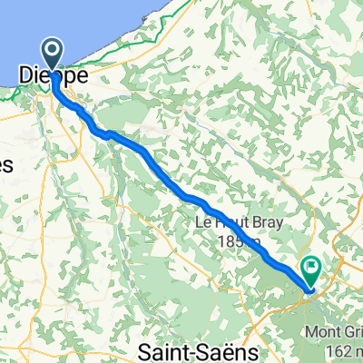
Dieppe - Forges-les-Eaux
A cycling route starting in Dieppe, Normandy, France.
Overview
About this route
The route is virtually a dedicated cyclepath throughout. The DFDS ferry is only about 2 km from the start of L'Avenue Verte. The route follows a well-surfaced path leading to Camping Miniere in Forges-les-Eaux - a total distance of 56.4 km.
- -:--
- Duration
- 56.3 km
- Distance
- 255 m
- Ascent
- 113 m
- Descent
- ---
- Avg. speed
- 173 m
- Max. altitude

Route quality
Waytypes & surfaces along the route
Waytypes
Path
47.3 km
(84 %)
Quiet road
3.9 km
(7 %)
Surfaces
Paved
52.9 km
(94 %)
Asphalt
51.3 km
(91 %)
Paved (undefined)
1.1 km
(2 %)
Continue with Bikemap
Use, edit, or download this cycling route
You would like to ride Dieppe - Forges-les-Eaux or customize it for your own trip? Here is what you can do with this Bikemap route:
Free features
- Save this route as favorite or in collections
- Copy & plan your own version of this route
- Sync your route with Garmin or Wahoo
Premium features
Free trial for 3 days, or one-time payment. More about Bikemap Premium.
- Navigate this route on iOS & Android
- Export a GPX / KML file of this route
- Create your custom printout (try it for free)
- Download this route for offline navigation
Discover more Premium features.
Get Bikemap PremiumFrom our community
Other popular routes starting in Dieppe
 D1AvenueVerte
- Distance
- 72.5 km
- Ascent
- 385 m
- Descent
- 276 m
- Location
- Dieppe, Normandy, France
 Dieppe - Forges-les-Eaux
- Distance
- 56.3 km
- Ascent
- 255 m
- Descent
- 113 m
- Location
- Dieppe, Normandy, France
 Day 1 - Neuville Ferrieres
- Distance
- 38.6 km
- Ascent
- 142 m
- Descent
- 61 m
- Location
- Dieppe, Normandy, France
 Chasse-marée Dieppe-Paris
- Distance
- 198.9 km
- Ascent
- 701 m
- Descent
- 667 m
- Location
- Dieppe, Normandy, France
 Carlisle Normandy 1
- Distance
- 37.1 km
- Ascent
- 137 m
- Descent
- 49 m
- Location
- Dieppe, Normandy, France
 Dieppe - Le Havre (Eurovelo 4)
- Distance
- 149.6 km
- Ascent
- 1,498 m
- Descent
- 1,509 m
- Location
- Dieppe, Normandy, France
 Dieppe Port to Paris (official Avenue Verte route via Gisors)
- Distance
- 248 km
- Ascent
- 607 m
- Descent
- 565 m
- Location
- Dieppe, Normandy, France
 Arcade de la Bourse, Dieppe à Rue d'Eu, Ault
- Distance
- 42.9 km
- Ascent
- 442 m
- Descent
- 378 m
- Location
- Dieppe, Normandy, France
Open it in the app