

2004 (Excursión- Unquera)
A cycling route starting in San Vicente de la Barquera, Cantabria, Spain.
Overview
About this route
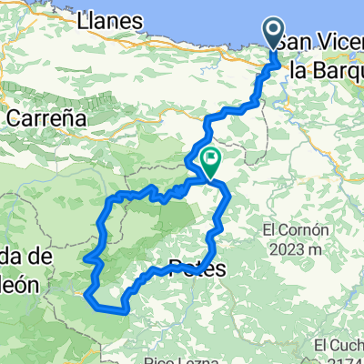
No. 1 - Unquera - San Vicente - Cabezón de la Sal - Sopeña - Carmona - Puentenansa - Quintanilla - Camijanes - Pesues - Unquera.
1st Pass: Carmona. 6 km climb
2nd Pass: Ozalba 6.2 km climb
- -:--
- Duration
- 89.7 km
- Distance
- 1,198 m
- Ascent
- 1,201 m
- Descent
- ---
- Avg. speed
- ---
- Max. altitude

Route quality
Waytypes & surfaces along the route
Waytypes
Cycleway
26.9 km
(30 %)
Quiet road
9 km
(10 %)
Surfaces
Paved
21.5 km
(24 %)
Asphalt
21.5 km
(24 %)
Undefined
68.1 km
(76 %)
Route highlights
Points of interest along the route
Point of interest after 46 km
Cumbre/ Collado: Carmona 6 Km. de ascensión
Point of interest after 51.9 km
1º - Avituallamiento
Point of interest after 62.7 km
Cumbre/ Collado: Ozalba 6,2 Km. de ascensión
Point of interest after 79.8 km
2º Avituallamiento Invitación por Eloy
Accommodation after 89.7 km
Hotel: Canal.
Continue with Bikemap
Use, edit, or download this cycling route
You would like to ride 2004 (Excursión- Unquera) or customize it for your own trip? Here is what you can do with this Bikemap route:
Free features
- Save this route as favorite or in collections
- Copy & plan your own version of this route
- Split it into stages to create a multi-day tour
- Sync your route with Garmin or Wahoo
Premium features
Free trial for 3 days, or one-time payment. More about Bikemap Premium.
- Navigate this route on iOS & Android
- Export a GPX / KML file of this route
- Create your custom printout (try it for free)
- Download this route for offline navigation
Discover more Premium features.
Get Bikemap PremiumFrom our community
Other popular routes starting in San Vicente de la Barquera
 11.Faros del Norte: El Peral - faro de Llanes - faro de Ribadesella - Ribadesella
- Distance
- 66 km
- Ascent
- 760 m
- Descent
- 818 m
- Location
- San Vicente de la Barquera, Cantabria, Spain
 San Vicente de la Barquera - Cantabria
- Distance
- 103 km
- Ascent
- 1,636 m
- Descent
- 1,636 m
- Location
- San Vicente de la Barquera, Cantabria, Spain
 Picos Europa Dan
- Distance
- 97.1 km
- Ascent
- 2,355 m
- Descent
- 2,276 m
- Location
- San Vicente de la Barquera, Cantabria, Spain
 2004 (Excursión- Unquera)
- Distance
- 89.7 km
- Ascent
- 1,198 m
- Descent
- 1,201 m
- Location
- San Vicente de la Barquera, Cantabria, Spain
 Triatlón de San Vicente de la Barquera
- Distance
- 19.9 km
- Ascent
- 292 m
- Descent
- 292 m
- Location
- San Vicente de la Barquera, Cantabria, Spain
 3 San Vicente - Llanes
- Distance
- 47.9 km
- Ascent
- 1,032 m
- Descent
- 1,022 m
- Location
- San Vicente de la Barquera, Cantabria, Spain
 Barrio Lamadrid, Valdáliga a Barrio Lamadrid, Valdáliga
- Distance
- 25.9 km
- Ascent
- 466 m
- Descent
- 476 m
- Location
- San Vicente de la Barquera, Cantabria, Spain
 Mittelgebirge und über Unquera und Pesues zurück nach San Vicente
- Distance
- 53.8 km
- Ascent
- 922 m
- Descent
- 907 m
- Location
- San Vicente de la Barquera, Cantabria, Spain
Open it in the app