

Switzerland
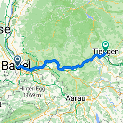
Stage4_Basilea_Nidau
A cycling route starting in Birsfelden, Basel-Landschaft, Switzerland.
Overview
About this route
null
- 6 h
- Duration
- 90.3 km
- Distance
- 996 m
- Ascent
- 835 m
- Descent
- 15 km/h
- Avg. speed
- 742 m
- Max. altitude

Part of
Switzerland
10 stages
Route quality
Waytypes & surfaces along the route
Waytypes
Quiet road
25.3 km
(28 %)
Road
11.7 km
(13 %)
Surfaces
Paved
69.5 km
(77 %)
Unpaved
1.8 km
(2 %)
Asphalt
68.6 km
(76 %)
Gravel
1.8 km
(2 %)
Continue with Bikemap
Use, edit, or download this cycling route
You would like to ride Stage4_Basilea_Nidau or customize it for your own trip? Here is what you can do with this Bikemap route:
Free features
- Save this route as favorite or in collections
- Copy & plan your own version of this route
- Split it into stages to create a multi-day tour
- Sync your route with Garmin or Wahoo
Premium features
Free trial for 3 days, or one-time payment. More about Bikemap Premium.
- Navigate this route on iOS & Android
- Export a GPX / KML file of this route
- Create your custom printout (try it for free)
- Download this route for offline navigation
Discover more Premium features.
Get Bikemap PremiumFrom our community
Other popular routes starting in Birsfelden
 Von Basel bis Waldshut-Tiengen
- Distance
- 71.3 km
- Ascent
- 358 m
- Descent
- 278 m
- Location
- Birsfelden, Basel-Landschaft, Switzerland
 Sporttag Bäumlihof 2015
- Distance
- 38.8 km
- Ascent
- 242 m
- Descent
- 235 m
- Location
- Birsfelden, Basel-Landschaft, Switzerland
 slowup 2008
- Distance
- 46.8 km
- Ascent
- 155 m
- Descent
- 150 m
- Location
- Birsfelden, Basel-Landschaft, Switzerland
 Basel - Passau
- Distance
- 717.1 km
- Ascent
- 765 m
- Descent
- 718 m
- Location
- Birsfelden, Basel-Landschaft, Switzerland
 kleine Gempenrunde
- Distance
- 35.4 km
- Ascent
- 1,086 m
- Descent
- 883 m
- Location
- Birsfelden, Basel-Landschaft, Switzerland
 1. Etappe: Basel - Laufenburg Alpen 2012
- Distance
- 41.1 km
- Ascent
- 111 m
- Descent
- 62 m
- Location
- Birsfelden, Basel-Landschaft, Switzerland
 Steinen-Schopfheim-Tegernau-Kandern
- Distance
- 64.5 km
- Ascent
- 516 m
- Descent
- 514 m
- Location
- Birsfelden, Basel-Landschaft, Switzerland
 Dreiländer route + Jura route
- Distance
- 35.7 km
- Ascent
- 305 m
- Descent
- 308 m
- Location
- Birsfelden, Basel-Landschaft, Switzerland
Open it in the app