

Subida al Calamón Alto
A cycling route starting in El Ronquillo, Andalusia, Spain.
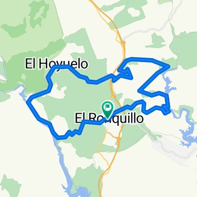
Overview
About this route
Subida de 2.2 kilómetros, con un desnivel medio de un 5,5%.
La parte más dura se encuentra a los 400m, subiendo a porcentajes del 8 al 18%, siendo especialmente duro el tramo anterior que va de los 750 a los 850m, con una pendiente que nunca baja del 13%, llegando hasta el 18%.
- -:--
- Duration
- 2.3 km
- Distance
- 119 m
- Ascent
- 19 m
- Descent
- ---
- Avg. speed
- ---
- Max. altitude

Route quality
Waytypes & surfaces along the route
Waytypes
Track
2.3 km
(100 %)
Surfaces
Unpaved
2.3 km
(100 %)
Ground
2.3 km
(100 %)
Continue with Bikemap
Use, edit, or download this cycling route
You would like to ride Subida al Calamón Alto or customize it for your own trip? Here is what you can do with this Bikemap route:
Free features
- Save this route as favorite or in collections
- Copy & plan your own version of this route
- Sync your route with Garmin or Wahoo
Premium features
Free trial for 3 days, or one-time payment. More about Bikemap Premium.
- Navigate this route on iOS & Android
- Export a GPX / KML file of this route
- Create your custom printout (try it for free)
- Download this route for offline navigation
Discover more Premium features.
Get Bikemap PremiumFrom our community
Other popular routes starting in El Ronquillo
 Marcha Solidaria El Ronquillo 2011
- Distance
- 37 km
- Ascent
- 510 m
- Descent
- 509 m
- Location
- El Ronquillo, Andalusia, Spain
 tramo bajada baterias
- Distance
- 0.9 km
- Ascent
- 12 m
- Descent
- 54 m
- Location
- El Ronquillo, Andalusia, Spain
 IX Marcha Cicloturista El Ronquillo "LA SOLIDARIA" (Ruta Corta)
- Distance
- 31.9 km
- Ascent
- 498 m
- Descent
- 498 m
- Location
- El Ronquillo, Andalusia, Spain
 RECORRIDO CICLISTA SE-186 VIA PECUARIA
- Distance
- 24.8 km
- Ascent
- 366 m
- Descent
- 418 m
- Location
- El Ronquillo, Andalusia, Spain
 Encerrona Ronquillera 2013
- Distance
- 39.5 km
- Ascent
- 725 m
- Descent
- 725 m
- Location
- El Ronquillo, Andalusia, Spain
 La Solidaria 2015
- Distance
- 41.6 km
- Ascent
- 700 m
- Descent
- 700 m
- Location
- El Ronquillo, Andalusia, Spain
 BICI DESDE LAGOS SERRANO HASTA N-630
- Distance
- 8.5 km
- Ascent
- 231 m
- Descent
- 195 m
- Location
- El Ronquillo, Andalusia, Spain
 Subida al Calamón Alto
- Distance
- 2.3 km
- Ascent
- 119 m
- Descent
- 19 m
- Location
- El Ronquillo, Andalusia, Spain
Open it in the app