

Rando-St-Hilaire
A cycling route starting in Richelieu, Quebec, Canada.
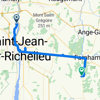
Overview
About this route
Chambly-St-Hilaire on a beautiful road.
Attention: Chemin du Richelieu is sometimes quite busy but the speed limit is not too high.
- -:--
- Duration
- 44.4 km
- Distance
- 127 m
- Ascent
- 126 m
- Descent
- ---
- Avg. speed
- ---
- Max. altitude
Route quality
Waytypes & surfaces along the route
Waytypes
Road
19.5 km
(44 %)
Quiet road
5.8 km
(13 %)
Surfaces
Paved
34.2 km
(77 %)
Unpaved
0.4 km
(1 %)
Asphalt
31.1 km
(70 %)
Paved (undefined)
3.1 km
(7 %)
Continue with Bikemap
Use, edit, or download this cycling route
You would like to ride Rando-St-Hilaire or customize it for your own trip? Here is what you can do with this Bikemap route:
Free features
- Save this route as favorite or in collections
- Copy & plan your own version of this route
- Sync your route with Garmin or Wahoo
Premium features
Free trial for 3 days, or one-time payment. More about Bikemap Premium.
- Navigate this route on iOS & Android
- Export a GPX / KML file of this route
- Create your custom printout (try it for free)
- Download this route for offline navigation
Discover more Premium features.
Get Bikemap PremiumFrom our community
Other popular routes starting in Richelieu
 Rando-St-Hilaire
- Distance
- 44.4 km
- Ascent
- 127 m
- Descent
- 126 m
- Location
- Richelieu, Quebec, Canada
 J1b: Chambly - Farnham
- Distance
- 40.2 km
- Ascent
- 73 m
- Descent
- 40 m
- Location
- Richelieu, Quebec, Canada
 Rue Panet 696, Richelieu to Rue Panet 790, Richelieu
- Distance
- 16.6 km
- Ascent
- 61 m
- Descent
- 34 m
- Location
- Richelieu, Quebec, Canada
 2814 Ch du Canal, Chambly to 1215 Rue Plessis, Montréal
- Distance
- 30.3 km
- Ascent
- 99 m
- Descent
- 97 m
- Location
- Richelieu, Quebec, Canada
 Parcours détendu
- Distance
- 32.3 km
- Ascent
- 62 m
- Descent
- 64 m
- Location
- Richelieu, Quebec, Canada
 Boucle Montérégienne
- Distance
- 75.7 km
- Ascent
- 174 m
- Descent
- 167 m
- Location
- Richelieu, Quebec, Canada
 De Richelieu à Rougemont
- Distance
- 71.1 km
- Ascent
- 224 m
- Descent
- 225 m
- Location
- Richelieu, Quebec, Canada
 Itinéraire modéré en Chambly
- Distance
- 23.8 km
- Ascent
- 502 m
- Descent
- 510 m
- Location
- Richelieu, Quebec, Canada
Open it in the app