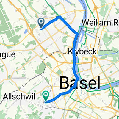
CYCLING THE RHINE: Route Approach G
A cycling route starting in Saint-Louis, Grand Est, France.
Overview
About this route
From EuroAirport (Mulhouse-Basel-Freiburg) to Basel Railway Station (SBB-Swiss).
- -:--
- Duration
- 7.8 km
- Distance
- 43 m
- Ascent
- 25 m
- Descent
- ---
- Avg. speed
- ---
- Max. altitude
Route quality
Waytypes & surfaces along the route
Waytypes
Quiet road
1.1 km
(14 %)
Pedestrian area
1 km
(13 %)
Surfaces
Paved
7 km
(90 %)
Unpaved
0.2 km
(2 %)
Asphalt
7 km
(90 %)
Gravel
0.2 km
(2 %)
Undefined
0.6 km
(8 %)
Route highlights
Points of interest along the route
Point of interest after 0 km
Saint-Louis La Chaussee Railway Station SNCF (France)
Point of interest after 0 km
Take the EXIT to France from the airport, to cycle directly to the Rhine Route alongside the Huningue Canal.
Point of interest after 0 km
Join the Rhine Route at this point.
Point of interest after 0 km
Take the EXIT to Switzerland to cycle directly to Basel (SBB) Raileay Station.
Point of interest after 2.4 km
Saint-Louis Railway Station SNCF (France)
Point of interest after 3.8 km
Border between Switzerland and France. Customs & Immigration stop possible. NOTE: Switzerland is now a signatory to the Schengen Agreement.
Point of interest after 5.1 km
Weil am Rhein Railway Station. DBB (German)
Continue with Bikemap
Use, edit, or download this cycling route
You would like to ride CYCLING THE RHINE: Route Approach G or customize it for your own trip? Here is what you can do with this Bikemap route:
Free features
- Save this route as favorite or in collections
- Copy & plan your own version of this route
- Sync your route with Garmin or Wahoo
Premium features
Free trial for 3 days, or one-time payment. More about Bikemap Premium.
- Navigate this route on iOS & Android
- Export a GPX / KML file of this route
- Create your custom printout (try it for free)
- Download this route for offline navigation
Discover more Premium features.
Get Bikemap PremiumFrom our community
Other popular routes starting in Saint-Louis
FRA-GER-SUI- Distance
- 58.1 km
- Ascent
- 334 m
- Descent
- 337 m
- Location
- Saint-Louis, Grand Est, France
Saint-Louis-Biederthal-Oberwil-Saint-Louis (Shortened)- Distance
- 54.3 km
- Ascent
- 606 m
- Descent
- 606 m
- Location
- Saint-Louis, Grand Est, France
CYCLING THE RHINE: Route Approach G- Distance
- 7.8 km
- Ascent
- 43 m
- Descent
- 25 m
- Location
- Saint-Louis, Grand Est, France
Landskron Route- Distance
- 28 km
- Ascent
- 256 m
- Descent
- 259 m
- Location
- Saint-Louis, Grand Est, France
Suisse - Trajet planifie pour sept 2014- Distance
- 1,180.8 km
- Ascent
- 5,506 m
- Descent
- 5,513 m
- Location
- Saint-Louis, Grand Est, France
St-Louis-Ranspach(s)-Blotz-Stetten-Geispitzen-Kembs-St-Louis- Distance
- 71.8 km
- Ascent
- 341 m
- Descent
- 340 m
- Location
- Saint-Louis, Grand Est, France
Saint-Louis nach Lörrach- Distance
- 12.4 km
- Ascent
- 102 m
- Descent
- 26 m
- Location
- Saint-Louis, Grand Est, France
Velo Suisse no 1 - Sept 2014 - Trajet effectue- Distance
- 1,009.6 km
- Ascent
- 5,208 m
- Descent
- 5,210 m
- Location
- Saint-Louis, Grand Est, France
Open it in the app

