

Trainingsrunde 3(5) 2010
A cycling route starting in Aachen, North Rhine-Westphalia, Germany.
Overview
About this route
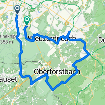
Wegbeschreibung:
AC – Vennbahn – Walheim – Schmithof – Sief – Hof Möris – Raeren – Neudorf – Hof Bovendriesch – Schloss Waldenburgshaus - Kettenis – Hof Rabotratherfeld – Rabotrath – Preismühle – Astenet – Eynatterheide (Waschanlage) – AC
Terrain:
Eher Flache Runde, mit ein paar kurzen Anstiegen: Ausgang Walheim; in Raeren und Ausgang Neudorf. Auf den belgischen Strassen und Wegen ist mit Schlaglöchern zu rechnen:).
- -:--
- Duration
- 53 km
- Distance
- 378 m
- Ascent
- 372 m
- Descent
- ---
- Avg. speed
- 326 m
- Avg. speed
Route quality
Waytypes & surfaces along the route
Waytypes
Path
17.2 km
(32 %)
Quiet road
16.7 km
(31 %)
Surfaces
Paved
40.4 km
(76 %)
Unpaved
0.1 km
(<1 %)
Asphalt
37.5 km
(71 %)
Concrete
1.7 km
(3 %)
Continue with Bikemap
Use, edit, or download this cycling route
You would like to ride Trainingsrunde 3(5) 2010 or customize it for your own trip? Here is what you can do with this Bikemap route:
Free features
- Save this route as favorite or in collections
- Copy & plan your own version of this route
- Sync your route with Garmin or Wahoo
Premium features
Free trial for 3 days, or one-time payment. More about Bikemap Premium.
- Navigate this route on iOS & Android
- Export a GPX / KML file of this route
- Create your custom printout (try it for free)
- Download this route for offline navigation
Discover more Premium features.
Get Bikemap PremiumFrom our community
Other popular routes starting in Aachen
 Trainingsrunde 3(5) 2010
- Distance
- 53 km
- Ascent
- 378 m
- Descent
- 372 m
- Location
- Aachen, North Rhine-Westphalia, Germany
 Köpfchen-Lichtenbusch-Vennbahn
- Distance
- 26.9 km
- Ascent
- 193 m
- Descent
- 174 m
- Location
- Aachen, North Rhine-Westphalia, Germany
 12-01-17 Kleine Mergellandrunde 47km-629hm
- Distance
- 47.5 km
- Ascent
- 473 m
- Descent
- 473 m
- Location
- Aachen, North Rhine-Westphalia, Germany
 Zweifall +Hohes Venn
- Distance
- 69.6 km
- Ascent
- 564 m
- Descent
- 564 m
- Location
- Aachen, North Rhine-Westphalia, Germany
 Durch den Aachener Stadtwald
- Distance
- 26.7 km
- Ascent
- 320 m
- Descent
- 320 m
- Location
- Aachen, North Rhine-Westphalia, Germany
 TJs extreme :)
- Distance
- 50.6 km
- Ascent
- 615 m
- Descent
- 612 m
- Location
- Aachen, North Rhine-Westphalia, Germany
 Aachen Süd, mit entspanntem Mittelstück
- Distance
- 14.5 km
- Ascent
- 257 m
- Descent
- 248 m
- Location
- Aachen, North Rhine-Westphalia, Germany
 Soers und Wurmtal
- Distance
- 16.1 km
- Ascent
- 145 m
- Descent
- 155 m
- Location
- Aachen, North Rhine-Westphalia, Germany
Open it in the app